Saturday, September 25, 2021

Disappointment on Disappointment Peak

 Carly Kovacik and I slogged up to Amphitheater Lake during mid September, a high alpine body of water, that we subsequently traversed around to the left. We then ascended toward a band of cliffs that would give us access to the upper slopes of Disappointment Peak. Six to twelve inches of snow fell across this area during the past 24 hours, but footing was pretty firm and trail breaking was no problem. We reached the cliffs and started observing cumulus clouds bubbling upwards. There was a chance that snow showers and possible thunderstorms would develop, and given our exposed location, we decided not to advance to the summit of Disappointment Peak. It turns out the weather progressively improved as the day advanced, and weather impacts on a summit attempt would have been a non-issue. Nevertheless, we had to act on the observations at hand, and those observations said "go down." 

We made the best of our situation and completed a 17 mile hike back to our car, trekking past Bradley Lake followed by Taggart Lake. After those lakes we reached the main park road, hiked north, and then cut west from the park road across Lupine Meadows to our vehicle. Photogenic views were ever-present during our low elevation trek, but unfortunately still no Grizzly sightings.

Google map location is here.

Thursday, September 23, 2021

Yellowstone National Park - Grand Prismatic Spring / Mammoth Hot Springs / Gardiner, Montana

 Carly Kovacik and myself explored Yellowstone National Park a few days before the start of fall. The park was about what we expected...lot's of geothermal activity, abundant natural beauty, occasional wildlife, and big crowds (though the crowds were probably not as bad as peak summer numbers). Carly and I stopped at Old Faithful, and discovered we just missed an eruption. So we headed north on Highway 191 and walked around the boardwalk next to Grand Prismatic Spring. This is the third largest hot spring in the world, and largest in the United States. The water was boiling, steam was swirling over the landscape, and a multitude of colors covered the soil under the water...a product of thermophile bacteria. There was also an overlook sitting atop a bluff that gave an impressive view of the colorful spring from up high, which we accessed from a trailhead located a mile or so south of the boardwalk.

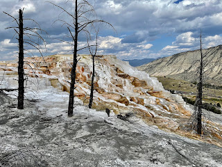
After Grand Prismatic, we headed north on 191 to Highway 89, and then drove an hour to Mammoth Hot Springs. The most impressive part of Mammoth is the multiple terraces that cover the landscape, which form when acid dissolves limestone that subsequently solidified at the surface. We hiked around the terraces for about 30 minutes, but had to cut things short due to a strong shower spreading east across our location. We decided to eat an early dinner just north of the border in Gardiner, Montana, stopping at the Iron Horse Bar and Grill. That place is awesome, especially when seated outside on the patio which overlooks the surrounding mountains and the Yellowstone River flowing swiftly below. After a fantastic meal and a couple of beers we drove south back into the park and tried to watch the last Old Faithful eruption lit by daylight. We made it to the geyser just in time to watch its last spurt of steam and water. We then explored the inside of the Old Faithful Inn, which is a really impressive cathedral-like wooden inn that captures the setting sun perfectly. 

YouTube video is here: [https://www.youtube.com/watch?v=pWt_PnVqvhY]. Google map location is here.

Saturday, September 18, 2021

Middle Teton - Southwest Couloir Route

 Carly Kovacik and I summited Middle Teton via the southwest couloir on September 17th. The first four miles consisted of steep hiking through a forest. Views rapidly opened up once we reached Garnet Canyon. We traversed the north wall of the canyon, and then performed a couple of stream crossings in between boulder hopping. Boulder scrambling and hopping would be a prominent part of the remainder of our day, as sections of flat ground or rock slabs were few and far between as we ascended toward the saddle separating South and Middle Teton. As we continued our journey up canyon, we passed a few dwindling/nearly extinct glaciers, and also scrambled past a couple of minor water falls. We finally reached the previously mentioned saddle, and then turned north toward Middle Teton and the southwest couloir. 

We passed the top of a glacier/permanent snowfield, which gave way to a relatively flat bench that was followed by the entrance into the couloir. A steep ascent followed, mainly on loose rock and dirt. However, the loosest sections could be avoided by staying close to solid rock along the sidewalls of the couloir. In addition, a few class 3/4 climbing moves were occasionally used, particularly halfway up the couloir due to a chockstone-like feature blocking further progress upwards. We got around that crux move, and found ourselves facing an abyss off the northwest flank of Middle Teton. The vertical relief in elevation off the north side of the mountain was dramatic. We continued scrambling up to the final summit block, and finally acquired the top. This was the most exposed summit I've experienced while in the mountains, though the exposure wasn't precarious...just airy. 

After taking in the incredible views of Grand Teton, South Teton, surrounding Cathedral Group peaks, and the lower valleys located east and west, we began a cautious progressive descent down the mountain. As alluded to before, the crux move was the class 3/4 down climb from the chockstone. There were good foot placements for the crux move, which allowed us to breeze on through the last remaining technical obstacle. The remainder of our adventure involved route finding through boulder fields. We arrived back at the trailhead about an hour past sunset. Total elevation gain for Middle Teton from Lupine Meadow was around 6000 feet. Total mileage was between 12 and 13 miles. 

YouTube video is here: [https://www.youtube.com/watch?v=q-sgDphgKwg]. Google map location is here.

Thursday, September 16, 2021

Taylor Mountain - Wyoming

 Carly Kovacik and I hiked Taylor Mountain on September 16th. Taylor is a peak located near the Wyoming/Idaho border...slightly east of Victor, ID, west of Jackson, WY, and on the southwest periphery of Grand Teton National Park. We hiked through grizzly territory, but no bears were spotted. Nevertheless, our bear spray was close at hand. Otherwise, the trail was not too challenging. We ascended through forest, meadows, followed by some steeper slopes that gave access to the Taylor Mountain ridge. We traversed the ridge, which offered some class 2+ hiking at times. Trailhead to summit was 3000 feet of vertical, which we tackled in 2.5 hours. I have to add that after the hike, we ate dinner at the Knotty Pine restaurant. The food was amazing, and the late summer setting outdoors beneath a knotty pine gave us a real western homesteading dinner experience. I highly recommend the place for anyone looking for a meal in Victor, Idaho.

Google map location is here.

Mount Olympus - Wasatch Range

 I summited my first peak in the Wasatch Range on September 15th. Mount Olympus rises above the Wasatch Fault south of downtown Salt Lake City. The trail started steep up a fault scarp at the Olympus trailhead parking lot, and rarely did the steep relent during the remainder of my hike. Views of the city were abundant throughout most of the hike, and after switchbacking up along canyon walls, a bench-like-area was encountered perhaps 300'ish feet below the summit. The last pitch to the summit involved a few class 3 moves...but nothing is too exposed, and the scrambling was a welcomed challenge. A small bouldery ridge then leads to the summit proper. My watch indicated around 4000 feet of climbing, which I completed in around 2.5 hours.

Google map location is here.

Monday, September 06, 2021

Turkey Run State Park / Bazbeaux Pizza / Chatterbox Jazz Club

Amy Schreiber and I hiked ten miles through Turkey Run State Park located around an hour and a half west of Indianapolis. The park is a not so hidden gem of Indiana, which was evident by the hordes of people descending over the Labor Day weekend. With that being said, the park was a neat experience despite the crowds. Water has etched deep canyons and flume like features within the sandstone lining the banks of Sugar Creek. There is some minor scrambling here and there, and also a fun series of ladders that we used to descend down a couple of ledges. There were even times when water flowing through the overhanging canyons had a Zion/Subway like feel. 

After the hike, Amy and I drove back into Indianapolis and got pizza at Bazbeaux, which is located downtown. Our personalized pizza was awesome...consisting of pepperoni, chorizo, garlic, sun dried tomatoes, shredded mozzarella, feta, and red sauce. I promise you can't go wrong with that set of ingredients. Well, maybe the addition of basil would have perfected our concoction. Our pizza dinner was then followed by an hour of jazz at the Chatterbox, which had great atmosphere and music.

YouTube video is here: [https://www.youtube.com/watch?v=UqcCFdLLo0M]. Google map location is here.

Storm Chase//October 30, 2024//Northwest Oklahoma

 I drove out to Northwest Oklahoma to chase what appeared to be, at least initially, a favorable setup for tornadic supercells. Convective m...