Monday, September 19, 2022

Mount Niblock - Banff National Park

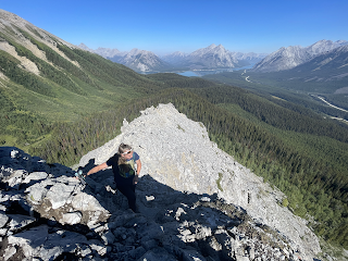
 Mount Niblock was a generally fun endeavor composed of sections of scrambling, a bit of exhilarating exposure, and an airy view of the surrounding mountains from the summit zone. The adventure begins from the standard viewing area for Lake Louise, which is an amazing sight in its own right. An hour or so of hiking brought Carly and I to the Lake Agnes Teahouse. We took a brief break at this spot, and then began making our way uphill through a glacially carved valley/cirque. Scree and boulders became more numerous, and steepness reached an apex at the base of a cliff band. There is a weakness through the cliffs, such that anything resembling climbing didn't exceed class 3, though there was mild exposure at times. 

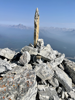
After passing the cliff band, we traveled through a boulder field, and then began an ascent toward a ridge that towered above. Route finding was interesting at times on the way to the ridge, but nothing too difficult. After reaching the ridge, we turned right toward the summit of Niblock. This last portion of the route to the summit was mainly a walk, with a few brief class 3 obstacles. However, the exposure increases a bit more on the way to the summit, but again nothing prohibitive. And at last, we reached the summit block and encountered a pinnacle of small rocks that held in place a thin two foot long spire-like summit ornament. We then took our pictures, refueled, and began rock skiing our way back down the mountain. We rewarded ourselves with tea (Carly) and lemonade (myself) at the Teahouse. It was quite a contrast being alone on top of an exhilarating mountain summit just a few hours earlier followed by the safety and crowdedness of the Teahouse.

YouTube video is here. Google map is here.


Monday, September 12, 2022

Mount Rundle - Banff National Park

 Another Alberta, Canada mountain for Carly and I. This time it was Mount Rundle, which features a trailhead that starts within a golf course located on the outskirts of Banff. The route is pretty straight forward. We followed a mainly straight and gradually ascending trail for several miles/kilometers, that transitioned to a series of switchbacks, followed by mildly steep scrambling up tree-root ledges. Above treeline, the route follows a steep ridge like feature. Then, a long section of hellishly steep scree is encountered...it is one of those one foot up three feet down kind of deals...not fun. Eventually easier ground is encountered near the summit of Rundle...though a map indicates that this is not the true Mount Rundle (instead, we did Mount Rundle 1?)...maybe a mere technicality? Regardless of whether we were atop the true Rundle, the view of the valley below was dramatic and impressive and well worth the effort. After a cool windy refresh, Carly and I made quick work of the route back down the mountain and back to the luxurious golf course.

YouTube vide is here. Google map is here.


Tent Ridge Horseshoe - Alberta, Canada

 Carly Kovacik and myself did the Tent Ridge Horseshoe trail in Alberta, Canada during early September. The trailhead is located south of Canmore in a pristine valley near Spray Lake Reservoir. At the trailhead, the recommended way to do the route is in a clockwise manner, as that allows a trekker to ascend several class 3 scrambling sections, which is generally easier than descending those sections. However, the scrambling sections are not terrible if one were to descend. Carly and I took the clockwise progression, moving through a nice alpine basin, then ascending up a ridge, passing through several class 3 moves, and then reaching the first of several minor peaks. We then descended from the first peak and ascended a second. The remainder of the route involved a long ridge, followed by a grueling descent down a scree covered trail. We then worked our way through forest before reaching the car. This is a great route following a long ridge with outstanding views of the surrounding Canadian Rockies and a beautiful valley below your feet.

YouTube video is here. Google map is here.


Storm Chase//October 30, 2024//Northwest Oklahoma

 I drove out to Northwest Oklahoma to chase what appeared to be, at least initially, a favorable setup for tornadic supercells. Convective m...