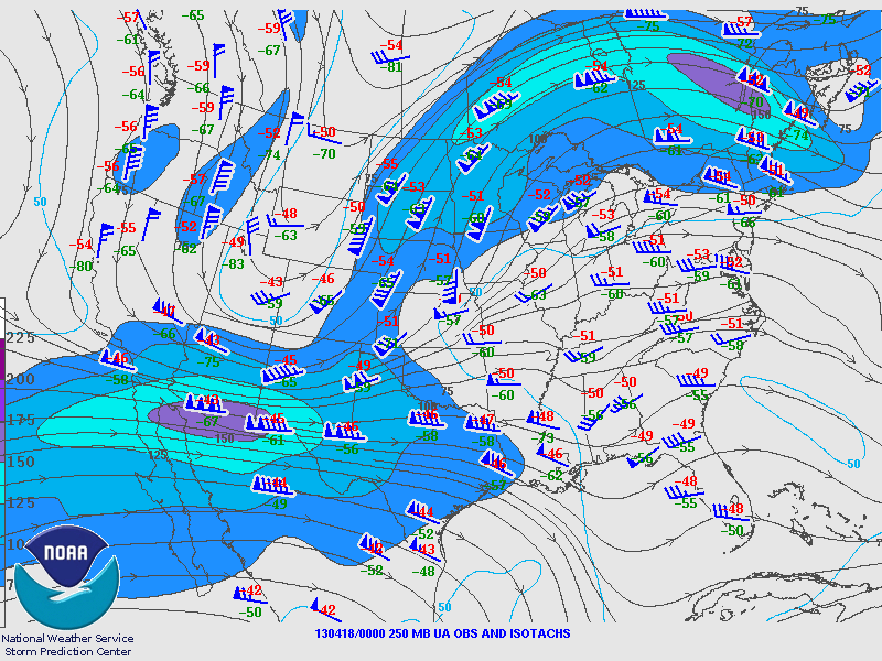
I got off of a mid shift at 8am on the morning of April 17th anticipating a decent shot at seeing a good supercell later in the afternoon. A frontal boundary was rapidly retreating northward toward central Oklahoma, with rich low-level moisture located to its south over southern Oklahoma into Texas. The big negative for this day was weak surface cyclogenesis and a cold airmass that was stubbornly locked over the southern high plains. After a few hours of sleep, I woke up for a quick data check, and then hit the road by 2 pm. After passing Lawton, OK, I headed south toward the Red River, and then went west on highway 70. One ongoing storm was already displaying supercellular characteristics west of Lawton. However, it was moving into a warm sector characterized by stratocumulus and high convective inhibition. Another cell approaching Frederick, OK was emanating off of steep low-level lapse rates, stronger boundary layer heating/destabilization, and higher MLCAPE values. Thus, this became my target storm. I sat in Frederick for 30 minutes waiting for the developing supercell to approach...and then decided to get aggressive and drove west on highway 5 toward the updraft base.
Updraft rotation was strengthening rapidly at this time (~520 pm), and inflow winds at the surface were screaming out of the east. However, shortly after I reached the low hanging updraft base, a cold RFD surged outwards, and the base took on a cold looking appearance. Nevertheless, I followed this messy HP storm east along highway 5, with a northward jog up highway 36 back to I-44. Just south of Lawton, I headed east on highway 7, and then went a few miles north and waited for the storm as it moved northeast. During my drive east of Lawton, other chasers reported power flashes over Lawton, which may have been caused by a brief tornado. The storm was a full fledged HP supercell as it crossed I-44, and I gave up the chase shortly after 715 pm. I took I-44 northeast for my drive back to Norman, and encountered heavy rain, quarter size hail, and strong winds. Although there were not many drivers on the turnpike, the few that I did come across were acting very stupidly. Every overpass I drove under was filled with cars trying to avoid the hail, with cars parked off the side of the road, cars parked in the slow lane of the turnpike, and cars parked on the shoulder adjacent to the median of the turnpike. Some Oklahomans never fail to disappoint when it comes to bone headed stupidity...I mean seriously, parking on the shoulder is fine, but out on the active roadway with cars approaching in near zero visibility???
Thursday, April 18, 2013
Wednesday, April 03, 2013
The Narrows - Wichita Mountains
I hiked through a canyon know as The Narrows in the Wichita Mountains on Saturday March 30th. Scenery and wildlife are abundant in this boulder filled scar that runs through the southern part of the wildlife refuge. After spending a couple of hours exploring the area, I drove a mile north and hiked to a waterfall (that was missing the most important ingredient...water) called "Forty Foot Hole." This canyon is less scenic than The Narrows, thus, the pictures posted below don't include The Hole.
Saturday, March 02, 2013
Granite Mountain East Ridge - Wichita Mountains
I spent the first morning of meteorological spring climbing the east ridge of Granite Mountain. I'm coming off mid-shifts, which unfortunately means waking up at 3am everyday since my body hasn't adjusted to a rotated sleep schedule. Thus, I left Norman early, 6am, and started hiking from the Charons Garden parking lot by 8am. After veering left off the main trail, I followed a faint trail down to a creek, ascended up the other side, traversed across a small ridge, descended into another creek bed that led north, and then reached the base of the east ridge of Granite. The initial part of the ridge includes fun scrambling across boulders and rock slabs. Then I slogged west up the ridge, dipped briefly into a valley, which was followed by an ascent up a headwall. The ridge then led northwest, eventually reaching the first of two gullies. This first gully is the pseudo-crux of the route, composed of a downclimb and then upclimb of easy 3rd class terrain. The second gully follows shortly after, and is descended by following a series of ramps. Third class terrain leads up to a sub-summit, followed by another small gully beneath the summit of Granite Mountain. After climbing 100 feet up rock slabs, the summit of Granite was obtained. I then descended into a bowl shaped valley located below the peak, and reascended back up to the east ridge, which led back down to the beginning of the route.
Sunday, February 10, 2013
Mount Lincoln Ridge Traverse - Wichita Mountains
I spent 3-4 hours during the late morning/early afternoon of February 8th traversing the long ridge that makes up the Mount Lincoln massif. The initial approach to the summit of Mount Lincoln was an easy hike with occasional scrambling. Then a cliff band was encountered, but a weakness in the cliff exists immediately west of the summit, which I took advantage of. After a short break, I headed south along the ridge toward a sub-summit. This summit was again surrounded by cliffs, but I found a narrow slot canyon that led to the top. There was a chock stone half way up the slot canyon, which inspired thoughts of an Aron Ralston type experience. I squeezed through an opening beneath the chock stone with arm still attached...drama avoided. I then continued my trek south along the ridge, with lots of fun scrambling and boulder hopping encountered.
A little while later, I reached the end of the ridge, then descended into a broad gulley that led west toward the Charons Garden parking lot. However, I came upon another small, 200 foot tall bouldery peak. So, I decided to climb to the top. Halfway up, I reached a 10 foot cliff. After a couple of easy class 5 moves, I traversed around ledges and found a class 3 approach to the summit. All in all it was an easy peak to climb. However, the class 5 down climb of the cliff was lingering in the back of my mind. I really hate down climbing cliffs! I didn't mention that the ledge leading back to the cliff is downsloping, which caused tremendous surges of adrenaline to flow through my body. I carefully made my way down to the edge of the cliff, and noticed a small pocket hold. I cleaned out the dirt from this hold, grasped it tightly with my right hand, and went for it, slowly lowering my body out past the cliff and then down. My legs were dangling about 4 feet above the ground, over a couple of small rocks. Without giving it a second thought, I jumped, and luckily didn't twist/break a leg. Unfortunately, I slashed open a gash in the palm of my right hand...luckily I got a tetanus booster shot a couple of years ago.
This experience was definitely an adventure in my opinion. I climbed the cliff, despite knowing that it would probably have to be down climbed later. But that is what adventure is all about...embracing uncertainty and fear, and going forward despite it all.
A little while later, I reached the end of the ridge, then descended into a broad gulley that led west toward the Charons Garden parking lot. However, I came upon another small, 200 foot tall bouldery peak. So, I decided to climb to the top. Halfway up, I reached a 10 foot cliff. After a couple of easy class 5 moves, I traversed around ledges and found a class 3 approach to the summit. All in all it was an easy peak to climb. However, the class 5 down climb of the cliff was lingering in the back of my mind. I really hate down climbing cliffs! I didn't mention that the ledge leading back to the cliff is downsloping, which caused tremendous surges of adrenaline to flow through my body. I carefully made my way down to the edge of the cliff, and noticed a small pocket hold. I cleaned out the dirt from this hold, grasped it tightly with my right hand, and went for it, slowly lowering my body out past the cliff and then down. My legs were dangling about 4 feet above the ground, over a couple of small rocks. Without giving it a second thought, I jumped, and luckily didn't twist/break a leg. Unfortunately, I slashed open a gash in the palm of my right hand...luckily I got a tetanus booster shot a couple of years ago.
This experience was definitely an adventure in my opinion. I climbed the cliff, despite knowing that it would probably have to be down climbed later. But that is what adventure is all about...embracing uncertainty and fear, and going forward despite it all.
Elk Mountain South Face - Wichita Mountains
I explored the south facing wall of Elk Mountain a few weeks ago. At first, I attempted to ascend one of the many gullies that leads to the summit plateau, but got cliffed out half way up. However, I had a good view of the Elk Slabs, which is a climbing wall I hope to attempt someday. After going back down to the base of the mountain, I hiked east to the col connecting Elk Mountain with Mount Lincoln. I then hiked up to the top of Elk Mountain, descended down the east-northeast side to the Sunset Picnic area, then hiked south on the Charon's Garden Wilderness Trail back to the parking lot.
Friday, January 04, 2013
Sunset Peak - Wichita Mountains
On January 2nd, I hiked a couple of miles west-southwest from the Sunset Picnic Area and reached the base of Sunset Peak in about an hour. I then ascended a gully, and reached a sub-peak, which required some class 3-4 climbing. I tried to downclimb this peak on the other side in which I ascended, but soon got cliffed out. So I reversed my route, and made it down via a couple of rock slabs. I then hiked northwest and obtained the primary peak which makes up the Sunset Peak massif. After taking a break and enjoying the view of the Charon's Garden Wilderness to my south-southeast, and the flat plains to my west, I spotted a prominent rocky peak off to my south. I hiked in that direction, ascended a gully, and was soon on top of the southern most peak of the massif. After another quick break, I hiked back to the trailhead, and drove back to Norman.
Subscribe to:
Posts (Atom)
Family Adventures in the Rockies // Grottos Ice Caves/Mount Sherman
My mom and nephew made a trip to central Colorado during early summer and we all had a blast hiking a couple of unique geological features,...
-
Cindy McCloskey, Ariel Cohen, Kim Klockow, and myself (Jonathan Garner) went climbing at Rocktown Gym in Oklahoma City on June 20th. The fo...
-
After working a midnight shift, I slept 3-4 hours, woke up at 130 pm, did a data check, dropped off a rent check, and then headed north on ...
-
Anca and I hit up different spots on the San Andreas Fault as we made our way south from Point Reyes to Parkfield, CA. Near Point Reyes, we ...