Amy Schreiber and myself were on an early January mission to find the origins of the Wabash River in west-central Ohio. Our mission was a success...the origin of the river that traverses all of Indiana starts off as a very small stream in the middle of corn fields a few miles south of Fort Recovery, Ohio. After braving a few minutes outdoors exploring the river in cold bitter windswept Ohio winter weather, we headed north into Fort Recovery. The fort that General Mad Anthony Wayne erected has been partially recreated. This is also the site of the greatest defeat in United States military history due to some brilliant battle strategy conjured up by Little Turtle and his unified tribal army. In addition, the site of the fort is also the reference point of the 1800 Greenville Treaty Boundary Line, the exact site of the survey point marked by a small circular plate (see image below). A lot of early American history, and pre-history, is packed into this region of Ohio...definitely worth a visit. [The origin point of the Wabash River is here. Fort Recovery is here.]
Tuesday, January 09, 2024
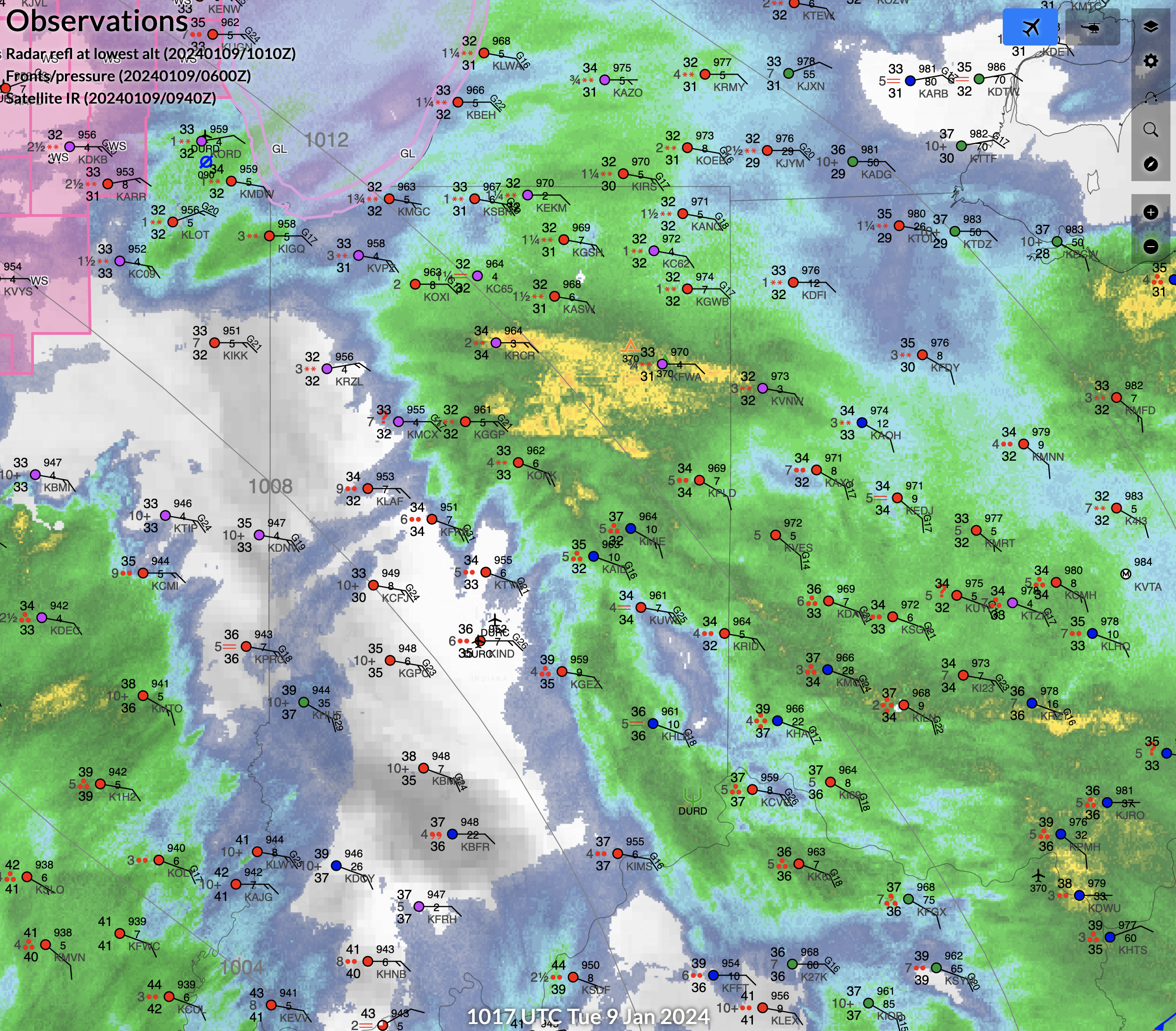
Light to Moderate Snowfall Across Northern Indiana: 9 January 2024
A zone of strong low to midlevel warm air advection aided in moderate precipitation rates across the northern half of Indiana during the pre-sunrise hours of January 9th, 2024. The airmass in the lowest couple of kilometers hovered very close to freezing, with surface temperatures at Fort Wayne slightly above 32F. Nevertheless, strong upward vertical motion through a deep layer favored moderately heavy snowfall rates that overcame the marginal low-level temperatures. However, the period of heavier snowfall was short-lived, as above freezing air near 850 mb quickly spread north across Indiana, bringing an end to snow and initiating a quick transition to rain.
![]() |
| Surface wet-bulb temperatures ranging from 32 to 33F over northern Indiana were marginally cold enough for snow. |
![]() |
| 850 mb temperatures show a robust transition from sub-freezing to above-freezing air going from north to south across the Midwest. |
![]() |
| 850 mb temperature advection. |
![]() |
| Short term model guidance, such as the RAP (shown above) did a good job predicting a band of 2-5 inch snowfall occurring across northern Indiana during the early morning hours of 9 January 2024. |
| A few inches of snow observed in southern Fort Wayne, Indiana at around 5 AM on 9 January 2024. |
Monday, January 08, 2024
Western Kansas Blizzard: 8 January 2024
An upper low centered over the Southern High Plains was focusing strong synoptic-scale ascent over western Kansas during the afternoon of January 8, 2024. In addition, a quasi-stationary frontal boundary was positioned from the Oklahoma Panhandle northeast across eastern Nebraska. An intense low to midlevel temperature gradient was oriented along the front and was yielding strong frontogenesis that was evident in radar reflectivity as a narrow contracting band of precipitation. Lightning was also observed over southwest Kansas in a zone of EPV reduction. Very strong ascent augmented by frontogenesis combined with reduced midlevel stability was subsequently resulting in heavy snowfall over western Kansas, and that snow was collocated with a post-frontal northerly barrier jet yielding gusts from 30 to 60 kt. Blizzard conditions with visibility reduced to a quarter mile or less were observed, and temperatures were in the teens and 20s. The threat to humans and livestock is substantial in those conditions.
![]() |
| A classic frontogenetic snowband was situated from west-central Kansas northeast to just east of McCook, Nebraska. |
![]() |
| Surface observations with regional radar reflectivity and frontal analysis overlaid. |
![]() |
| 925-850 mb frontogenesis. |
![]() |
| 850 mb wind speed. Note the intense post-frontal northerly barrier jet over western Kansas. |
Tuesday, January 02, 2024
Hanging Rock on the Wabash - Indiana
Amy Schreiber and myself explored an assortment of waterfalls in the vicinity of the Wabash River in central Indiana during late December. We also made time to visit Hanging Rock, which is an exposed fossilized coral reef that towers 50-100 feet above the Wabash. This feature also served as a landmark and meeting place for tribes of the past. Hanging Rock is located here.
Significant "All Hazards" Winter Storm January 8th-10th
Ensemble and deterministic model guidance is maintaining a consistent significant "all hazards" winter storm signal that migrates eastward across the central and eastern United States during the January 8th-10th period. By 12Z on the 9th, a vertically stacked deep-layer low is forecast by most guidance to be centered in the vicinity of southwestern Missouri. This will aid in the development of a pronounced surface cyclone and frontal wave advancing from Texas east across the Gulf Coast states. In addition, wind fields will be strong at all levels and upward vertical motion will be substantial. The operational GFS shows relatively high values of boundary-layer theta-e spreading north across the warm sector of the previously mentioned surface wave, and mid-level lapse rates will be fairly steep (>7 C/km), thus there is the potential for MLCAPE values to range from 1000-2000 J/kg, which is large for January. However, it's uncertain whether the warm sector will experience daytime surface insolation due to widespread low-level cloudiness, and that will likely impact convective mode evolution and possible tornado intensity. Nevertheless, current forecast wind fields are exceptionally favorable for long-track violent tornadoes within the previously mentioned surface warm sector (particularly far eastern Texas, southern Louisiana, southern Mississippi, and southern Alabama and adjacent Georgia and Florida panhandle), with mean 0-1 km streamwise vorticity >0.02 s-1.
Farther north, a mainly sub-zero deep-layer airmass will be in place from roughly the mid-Mississippi Valley northeast across the Great Lakes. In addition, very strong upward vertical motion is forecast to occur in the vicinity of a northeastward migrating 700 mb low. Thus, ingredients will likely be favorable for a band of heavy snowfall, the exact location obviously being a function of the near-surface freezing line and mesoscale ascent focused near the previously mentioned 700 mb low. Elsewhere in between the band of heavy snow to the north and severe weather to the south, heavy rain, gusty gradient winds, and perhaps embedded elevated thunderstorm activity will be probable.
![]() |
| Four-panel plot of 500 mb wind/heights valid 12Z 1/9/2024. |
![]() |
| Four-panel plot of 850 mb wind/heights/temperature valid 12Z 1/9/2024. |
![]() |
| GFS model forecast sounding representing the severe storm/tornado environment valid 09Z 1/9/2024 in southeast Mississippi. |
![]() |
| GFS 6-hour snowfall accumulation valid 00Z 1/10/2024. |
![]() |
| GFS model forecast sounding representing the heavy snow environment located across Michigan valid 21Z 1/9/2024. |
Sunday, December 31, 2023
New Years Eve Snow Dusting in Fort Wayne
A band of light snow moved across the Northeast Indiana/Fort Wayne region during the mid afternoon hours on New Years Eve (12/31/2023). Accumulations in Fort Wayne were generally at or below a half inch, and peak rates, again around 0.5 inch per hour, were fairly brief. This non-heavy snow event occurred as a plume of ascent rotated around a nearly vertically stacked low centered over southern Lower Michigan. The air mass was nearly saturated from the surface through the dendritic growth zone (DGZ) across NERN Indiana north into SRN Michigan, and surface wet bulb zero values were at or below freezing. Nevertheless, upward vertical motion, particularly through the DGZ, was weak at all scales, including synoptically, as well as at the meso. Furthermore, no mechanism was present to reduce stability. Thus, another entertaining one to two hour period of light snow was observed, but snowfall rates were well short of impactful levels.
![]() |
| Base reflectivity during peak snowfall rates occurring across northeastn Indiana. |
![]() |
| Water vapor imagery highlighting the stacked low positioned over southern Lower Michigan and associated plume of ascent spreading downstream across northern Indiana. |
![]() |
| Objectively analyzed surface observations during the time of peak snowfall rates occurring across northeast Indiana. |
Thursday, December 28, 2023
Monday, December 25, 2023
A Month In Fort Wayne, Indiana
I've completed nearly a month of residency in Fort Wayne, Indiana. Nice Midwest city with a bit of a downtown urban vibe. Rejuvenation is taking place, but the past is still retained in a lot of the architecture, which is a nice touch. I appreciate relics from the age of big industry, such as the General Electric buildings found at the Electric Works district. Classic 50s-70s Coney Dog restaurants and drive through burger joints can still be experienced as well.
![]() |
| The Lincoln Bank Tower for all the Art Deco lovers. |
![]() |
| Fort Wayne's Famous Coney Island, a place for great food (particularly coney dogs) in a classic American diner setting. |
![]() |
| A former building used by General Electric, now being converted into a market type setting full of shopping, food, etc. in the Electric Works district. |
![]() |
| An old fire station on Fairfield Ave. |
![]() |
| Fairfield Manor, at the corner of Fairfield and Creighton Avenues. |
![]() |
| Big Guy burger drive through, now closed, was popular in the region during the 60s and 70s. |
Saturday, December 23, 2023
Oregon Trail // California Hill, Nebraska
During my early December migration from California east to Indiana, I made a brief stop at California Hill, which is located west of Ogallala, Nebraska on Highway 30. This hill marked the first significant elevation gain that had to be tackled for those traveling west toward the Pacific Coast back in the 1800s. Supposedly, the last wagon to make the trek west on the Oregon Trail was in 1906. After parking just north of Highway 30, a short 1/4-1/2 mile hike brought me to deep ruts produced by thousands of wagons. It was a very surreal experience to be standing in the tracks made by those hearty migrants over a hundred years ago. And the vast openness of the prairie, the same prairie they looked out upon, probably in misery, also provided an extra connection to the past. The map location of California Hill is located here.
Family Adventures in the Rockies // Grottos Ice Caves/Mount Sherman
My mom and nephew made a trip to central Colorado during early summer and we all had a blast hiking a couple of unique geological features,...
-
Cindy McCloskey, Ariel Cohen, Kim Klockow, and myself (Jonathan Garner) went climbing at Rocktown Gym in Oklahoma City on June 20th. The fo...
-
After working a midnight shift, I slept 3-4 hours, woke up at 130 pm, did a data check, dropped off a rent check, and then headed north on ...
-
Anca and I hit up different spots on the San Andreas Fault as we made our way south from Point Reyes to Parkfield, CA. Near Point Reyes, we ...