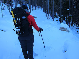
December 22nd was supposed to be the day that Cindy McCloskey and I hiked up to the Boulderfield (located adjacent to the north face of Longs Peak), camped overnight, and then ascended Storm Peak on the 23rd. The 22nd looked like a great day to establish a base camp, however, the 23rd was forecast to experience brutally strong winds and falling temperatures above 12,000 feet. Those conditions would likely prevent an attempt on Storm Peak, so we decided to skip our high altitude camping excursion, and instead make an attempt on Hallett Peak on the 22nd. We started up the Flattop Mountain trail at around 3am, and luckily found the snow along our route to be well packed below treeline.
It was a different story above treeline...some snowfields and drifts were firm, while others were soft, causing us to posthole up to our waist. One particular section was so bad that I decided to crawl 50 feet instead of constantly sinking in deep snow with each step. Eventually we regained the Flattop Mountain trail, which skirted past the chasm located above Dream and Emerald Lakes. We then left the trail and stayed close to the ridge line that leads toward Flattop Mountain, ascending snowfields and hopping over occasional boulders. Our shortcut eventually reconnected with the trail, which led up over a snowfield that sat next to a cornice hanging over a cliff ledge. I made quick progress from this area up to the "summit" of Flattop (which technically isn't a mountain, due to its lack of vertical prominence), and then waited a while for Cindy to catch up. I learned her legs were not feeling good, and this, in addition to strong winds, frigidly low wind chill values, and another 1/2 mile and 500 feet of vertical gain required to summit Hallett, led us to call it good and head back down. We followed the standard route all the way to treeline, and rapidly warmed up below as we bathed in the late afternoon sun and dying winds.
Tuesday, December 25, 2012
Rocky Mountain National Park, Twin Sisters, and Golden
Cindy McCloskey and I arrived in Boulder, CO on December 18th, and then
headed out to Rocky Mountain National Park on the 19th to view the
freshly snow covered mountains following a recent winter storm. A few
pictures of the Bear Lake area are posted below. On the 20th, we
decided to ascend Twin Sisters Peaks. Our original plan was to attempt
Hallett Peak. However, strong winds following in the wake of the winter
storm, as well as deep snow meant that Hallett Peak would be an
improbable goal. So at dawn we set off from the Twin Sisters trailhead,
and began the upward slog along a route that was covered in 1-4 feet of
snow. Needless to say, our pace was slowed down significantly as we
broke trail with our snowshoes. However, the view of the Longs Peak
massif was outstanding. Unfortunately, as we approached the summit of
Twin Sisters (west), winds strengthened to well above 50 mph, strong
enough that I wasn't able to stand upright. In addition, the long
battle breaking trail had taken much too long, such that we only had 3
hours of daylight remaining. So we turned around, short of the summit.
I managed to strain a muscle in the upper part of my leg on the way
down, so the next day was a rest day, and we hung out in Golden, CO,
eating at the Capitol Grill, and visiting the American Mountaineering
Museum.
Sunday, December 09, 2012
Meat Slab
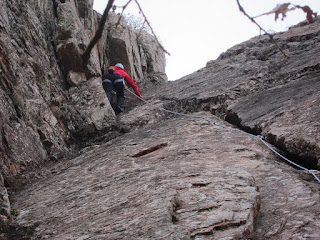
On Saturday December 9th, Cindy McCloskey and myself climbed several routes on the Meat Slab wall, which is located in The Narrows, a canyon in the southwestern portion of the Wichita Mountains. The first route we climbed was a crack that ascends up to a small ledge, followed by a crux block that gives access to the top of the wall. The crack was pretty easy 5.5 climbing, though the last piece of pro is placed at the top of the crack, resulting in 20 feet of runout climbing. After climbing this route a couple of times, I took a rightward trending variation that was slightly more exposed 5.6-5.7 climbing, again well above the last piece of pro. There were several water streaks farther right of the crack, which others climb when top roping. We didn't climb these streaks since there was nowhere to place pro, meaning we would of had to free solo 40 feet.
Thursday, November 29, 2012
Old Pictures
I wanted to post the pictures below before they are lost for eternity. Description of each scene is given after the image.
Tornado near Throckmorton, TX on April 7, 2002. Probably my best storm chase ever.
Developing stage of the Throckmorton, TX tornado.
Mature stage of the Throckmorton, TX tornado. Note the massive clear slot on the left/foreground wrapping cyclonically around the low-level mesocyclone.
Tornado near LaGrange, WY on June 5, 2009. I was much too close to this tornado, and my wind shield paid the price when softball size hail started to fall shortly after this picture was taken.
Wall cloud which preceded the LaGrange, WY tornado.
My first tornado observed, from May 16, 1999 near Pacific Junction, IA.
Old building in northwestern KS.
Sunset in northeastern CO.
Slot canyon in Tent Rocks, NM.
Sangre de Cristo mountains, CO.
Chimney Rock, NEB.
Morning light in Rocky Mountain National Park, CO.
Emerald Lake, Rocky Mountain National Park, CO.
Supercell thunderstorm over the Nebraska Panhandle.
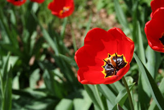
Spring flowers in Lincoln, NEB.
Weak tornado in southern KS on April 24, 2007.
Allen Fieldhouse, Lawrence, KS.
Daley Plaza, Dallas, TX.
El Capitan viewed from Guadalupe Peak, TX.
Outflow dominant wall cloud associated with a supercell in Western NEB.
Allen Fieldhouse, Lawrence, KS.
Estes Park, CO.
Approaching Granite Pass in Rocky Mountain National Park, CO.
Supercell thunderstorm in northeastern CO.
Developing supercell in central OK.
Rotating wall cloud in southern KS.
Approaching Buena Vista, CO.
View of Glacier Gorge and Longs Peak, CO.
Wheeler Peak, NM.
Sunset in southeastern SD.
Subscribe to:
Comments (Atom)
In Search of Original Prairie // Little Bend, South Dakota
I traveled from Omaha, Nebraska to Little Bend, South Dakota during early October to experience the prairie as the buffalo and first nation...

-
After working a midnight shift, I slept 3-4 hours, woke up at 130 pm, did a data check, dropped off a rent check, and then headed north on ...
-
I hiked 1.5 miles up to Strawberry Rock, a sea stack that has risen high above the ocean due to tectonic processes, which is located near th...
-
The following pictures were taken south of El Reno, OK, a hundred or so yards east of the intersection of Reuters and Radio Road. The TWIS...


