Wednesday, December 08, 2021

China Gulch Trail to Grizzly Lake - Trinity Alps

 I did around 15 miles and ascended 5500 feet on December 7th during a hike out and back to Grizzly Lake. The lake is accessed via China Gulch Trail, which is located in a remote section of the Trinity Alps southeast of Cecilville in Siskiyou County. I started the hike at sunrise and immediately encountered incinerated forestland, where trees in some sections are burnt down to the size of toothpicks due to wildfire occurring during the summer of 2021. Tree debris was scattered everywhere, and the soil had a soft clay like texture due to intense roasting under the fire. Otherwise, I ascended a ridge, and after its crest, descended into a valley and worked my way across increasingly complex terrain toward Grizzly Lake. Grizzly Creek produces abundant waterfalls, and could be a worthy photography objective during a future trek. Scenery opens up during the last mile to the lake, and the final challenge involves passage across a boulder field, followed by a 100 foot scramble up a series of gullies. From the gullies, I followed granite slabs a short distance and reached the lake. The weather was warm for December, and I spent 30 minutes soaking up rays before returning back to my truck, which I reached just after sunset. 

YouTube video is here. Google map location is here.


Saturday, December 04, 2021

Natural Bridges Oregon

 Zahaira Velez and myself celebrated the transition from November to December by exploring the coast of southwest Oregon. We drove from Eureka, CA to Brookings, Oregon, and from there hiked the steep trails surrounding Natural Bridges [located here in Google Maps]. The bridges are essentially a set of rock arches constantly pounded by surf. Zahaira and I spent an hour searching for a way to access the base of the bridges, but had no luck. We then found a trail that led across the bridges themselves. It was a narrow traverse, which was exhilarating for me, and the photography at the other side of the arch was classic Oregon. Anyone driving past on the 101 is a short hike away from obtaining one of the best views in all of coastal Oregon.


Monday, November 29, 2021

Gibson Cirque & Granite Lake

 I made an attempt on the summit of Gibson Peak in the Trinity Alps during late November, but got turned back by dwindling daylight and the need to return home in order to prep for a day shift in 12 hours. All was not lost though...I made it high up onto the slopes of Gibson and had a chance to explore the granite slabs that made up its former glacial cirque. I also gained an awesome view of Mount Shasta, and a lofty perspective of Granite Lake. Warm dry late November weather is not helping the California drought, but it is appreciated by those like me who want a few more treks into the alpine zone.

YouTube video is located here: [https://www.youtube.com/watch?v=p3tSGkplZRc]. Google map location is here.


Monday, October 11, 2021

Mount McLoughlin - Oregon Cascades

 I accomplished a second successful ascent of Mount McLoughlin in the Oregon Cascades during early October. Weather conditions were perfect...no wind, mild temperatures, abundant sunshine...an ideal weather window before the winter rains set in. Unfortunately, I suffered through a series of first world disasters, the first occurred immediately after starting my hike. Not five minutes after departing the trailhead, my brand new mountain climbing pants snagged on a log and ripped a giant hole below the knee. I think I was close to crying. To make matters worse, I took a wrong turn at the PCT junction and added an extra 3 miles to my epic...I became wise to my error, back tracked, took a short cut up a 500 foot lava hill, and reconnected with the path that guided me towards the summit. The rest of my day was uneventful. I made pretty quick work up the slopes of McLoughlin, then enjoyed a summit beverage before running downhill and back to my truck. Great day in the Cascades!

YouTube vide is here: [https://www.youtube.com/watch?v=uyX4_kgvfs0&t=1s]. Google map location is here.

Saturday, September 25, 2021

Disappointment on Disappointment Peak

 Carly Kovacik and I slogged up to Amphitheater Lake during mid September, a high alpine body of water, that we subsequently traversed around to the left. We then ascended toward a band of cliffs that would give us access to the upper slopes of Disappointment Peak. Six to twelve inches of snow fell across this area during the past 24 hours, but footing was pretty firm and trail breaking was no problem. We reached the cliffs and started observing cumulus clouds bubbling upwards. There was a chance that snow showers and possible thunderstorms would develop, and given our exposed location, we decided not to advance to the summit of Disappointment Peak. It turns out the weather progressively improved as the day advanced, and weather impacts on a summit attempt would have been a non-issue. Nevertheless, we had to act on the observations at hand, and those observations said "go down." 

We made the best of our situation and completed a 17 mile hike back to our car, trekking past Bradley Lake followed by Taggart Lake. After those lakes we reached the main park road, hiked north, and then cut west from the park road across Lupine Meadows to our vehicle. Photogenic views were ever-present during our low elevation trek, but unfortunately still no Grizzly sightings.

Google map location is here.

Thursday, September 23, 2021

Yellowstone National Park - Grand Prismatic Spring / Mammoth Hot Springs / Gardiner, Montana

 Carly Kovacik and myself explored Yellowstone National Park a few days before the start of fall. The park was about what we expected...lot's of geothermal activity, abundant natural beauty, occasional wildlife, and big crowds (though the crowds were probably not as bad as peak summer numbers). Carly and I stopped at Old Faithful, and discovered we just missed an eruption. So we headed north on Highway 191 and walked around the boardwalk next to Grand Prismatic Spring. This is the third largest hot spring in the world, and largest in the United States. The water was boiling, steam was swirling over the landscape, and a multitude of colors covered the soil under the water...a product of thermophile bacteria. There was also an overlook sitting atop a bluff that gave an impressive view of the colorful spring from up high, which we accessed from a trailhead located a mile or so south of the boardwalk.

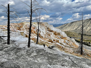
After Grand Prismatic, we headed north on 191 to Highway 89, and then drove an hour to Mammoth Hot Springs. The most impressive part of Mammoth is the multiple terraces that cover the landscape, which form when acid dissolves limestone that subsequently solidified at the surface. We hiked around the terraces for about 30 minutes, but had to cut things short due to a strong shower spreading east across our location. We decided to eat an early dinner just north of the border in Gardiner, Montana, stopping at the Iron Horse Bar and Grill. That place is awesome, especially when seated outside on the patio which overlooks the surrounding mountains and the Yellowstone River flowing swiftly below. After a fantastic meal and a couple of beers we drove south back into the park and tried to watch the last Old Faithful eruption lit by daylight. We made it to the geyser just in time to watch its last spurt of steam and water. We then explored the inside of the Old Faithful Inn, which is a really impressive cathedral-like wooden inn that captures the setting sun perfectly. 

YouTube video is here: [https://www.youtube.com/watch?v=pWt_PnVqvhY]. Google map location is here.

Saturday, September 18, 2021

Middle Teton - Southwest Couloir Route

 Carly Kovacik and I summited Middle Teton via the southwest couloir on September 17th. The first four miles consisted of steep hiking through a forest. Views rapidly opened up once we reached Garnet Canyon. We traversed the north wall of the canyon, and then performed a couple of stream crossings in between boulder hopping. Boulder scrambling and hopping would be a prominent part of the remainder of our day, as sections of flat ground or rock slabs were few and far between as we ascended toward the saddle separating South and Middle Teton. As we continued our journey up canyon, we passed a few dwindling/nearly extinct glaciers, and also scrambled past a couple of minor water falls. We finally reached the previously mentioned saddle, and then turned north toward Middle Teton and the southwest couloir. 

We passed the top of a glacier/permanent snowfield, which gave way to a relatively flat bench that was followed by the entrance into the couloir. A steep ascent followed, mainly on loose rock and dirt. However, the loosest sections could be avoided by staying close to solid rock along the sidewalls of the couloir. In addition, a few class 3/4 climbing moves were occasionally used, particularly halfway up the couloir due to a chockstone-like feature blocking further progress upwards. We got around that crux move, and found ourselves facing an abyss off the northwest flank of Middle Teton. The vertical relief in elevation off the north side of the mountain was dramatic. We continued scrambling up to the final summit block, and finally acquired the top. This was the most exposed summit I've experienced while in the mountains, though the exposure wasn't precarious...just airy. 

After taking in the incredible views of Grand Teton, South Teton, surrounding Cathedral Group peaks, and the lower valleys located east and west, we began a cautious progressive descent down the mountain. As alluded to before, the crux move was the class 3/4 down climb from the chockstone. There were good foot placements for the crux move, which allowed us to breeze on through the last remaining technical obstacle. The remainder of our adventure involved route finding through boulder fields. We arrived back at the trailhead about an hour past sunset. Total elevation gain for Middle Teton from Lupine Meadow was around 6000 feet. Total mileage was between 12 and 13 miles. 

YouTube video is here: [https://www.youtube.com/watch?v=q-sgDphgKwg]. Google map location is here.

Thursday, September 16, 2021

Taylor Mountain - Wyoming

 Carly Kovacik and I hiked Taylor Mountain on September 16th. Taylor is a peak located near the Wyoming/Idaho border...slightly east of Victor, ID, west of Jackson, WY, and on the southwest periphery of Grand Teton National Park. We hiked through grizzly territory, but no bears were spotted. Nevertheless, our bear spray was close at hand. Otherwise, the trail was not too challenging. We ascended through forest, meadows, followed by some steeper slopes that gave access to the Taylor Mountain ridge. We traversed the ridge, which offered some class 2+ hiking at times. Trailhead to summit was 3000 feet of vertical, which we tackled in 2.5 hours. I have to add that after the hike, we ate dinner at the Knotty Pine restaurant. The food was amazing, and the late summer setting outdoors beneath a knotty pine gave us a real western homesteading dinner experience. I highly recommend the place for anyone looking for a meal in Victor, Idaho.

Google map location is here.

Storm Chase // 16 April 2024 // Southeast Iowa Tornadic Supercell

 I chased southern Iowa on April 16th and was rewarded with an intense EF2 producing tornadic supercell west of Burlington, IA. I departed F...