Sunday, December 31, 2023

New Years Eve Snow Dusting in Fort Wayne

 A band of light snow moved across the Northeast Indiana/Fort Wayne region during the mid afternoon hours on New Years Eve (12/31/2023). Accumulations in Fort Wayne were generally at or below a half inch, and peak rates, again around 0.5 inch per hour, were fairly brief. This non-heavy snow event occurred as a plume of ascent rotated around a nearly vertically stacked low centered over southern Lower Michigan. The air mass was nearly saturated from the surface through the dendritic growth zone (DGZ) across NERN Indiana north into SRN Michigan, and surface wet bulb zero values were at or below freezing. Nevertheless, upward vertical motion, particularly through the DGZ, was weak at all scales, including synoptically, as well as at the meso. Furthermore, no mechanism was present to reduce stability. Thus, another entertaining one to two hour period of light snow was observed, but snowfall rates were well short of impactful levels.

Base reflectivity during peak snowfall rates occurring across northeastn Indiana.

Water vapor imagery highlighting the stacked low positioned over southern Lower Michigan and associated plume of ascent spreading downstream across northern Indiana.

700 mb heights and relative humidity depicting the saturation that was resolved by the RAP mesoanalysis as ascent associated with a low centered over southern Michigan spread east across northeast Indiana and adjacent Ohio and Michigan.

Objectively analyzed surface observations during the time of peak snowfall rates occurring across northeast Indiana.

RAP forecast sounding valid for northeast Indiana during the period of peak snowfall rates. Deep-layer saturation was present, but upward vertical motion was weak, particularly through the dendritic growth zone (-10 to -20 C layer). Snowfall accumulations were minor as a result.


Thursday, December 28, 2023

Monday, December 25, 2023

A Month In Fort Wayne, Indiana

 I've completed nearly a month of residency in Fort Wayne, Indiana. Nice Midwest city with a bit of a downtown urban vibe. Rejuvenation is taking place, but the past is still retained in a lot of the architecture, which is a nice touch. I appreciate relics from the age of big industry, such as the General Electric buildings found at the Electric Works district. Classic 50s-70s Coney Dog restaurants and drive through burger joints can still be experienced as well.

The Lincoln Bank Tower for all the Art Deco lovers.

Fort Wayne's Famous Coney Island, a place for great food (particularly coney dogs) in a classic American diner setting.

A former building used by General Electric, now being converted into a market type setting full of shopping, food, etc. in the Electric Works district.

An old fire station on Fairfield Ave.

Fairfield Manor, at the corner of Fairfield and Creighton Avenues.

Big Guy burger drive through, now closed, was popular in the region during the 60s and 70s.


Saturday, December 23, 2023

Oregon Trail // California Hill, Nebraska

 During my early December migration from California east to Indiana, I made a brief stop at California Hill, which is located west of Ogallala, Nebraska on Highway 30. This hill marked the first significant elevation gain that had to be tackled for those traveling west toward the Pacific Coast back in the 1800s. Supposedly, the last wagon to make the trek west on the Oregon Trail was in 1906. After parking just north of Highway 30, a short 1/4-1/2 mile hike brought me to deep ruts produced by thousands of wagons. It was a very surreal experience to be standing in the tracks made by those hearty migrants over a hundred years ago. And the vast openness of the prairie, the same prairie they looked out upon, probably in misery, also provided an extra connection to the past. The map location of California Hill is located here.


Friday, December 22, 2023

Assembly Hall // Indiana Hoosiers vs. Kansas Jayhawks

 I was fortunate to obtain tickets to the college basketball matchup featuring Kansas vs. Indiana at Assembly Hall in Bloomington, Indiana. These two programs are obviously the bluest of blue-bloods and a head to head meeting is something not to be missed. The game was close throughout, the crowd was superbly energized, and it was a great overall experience that I was glad to take part in. The arena itself features very vertical seating sections on two opposite sides of the court, which is definitely a unique type of college athletics venue. I was located high up in the balcony, but all the action on the court was totally viewable. Map location of Assembly Hall is here.


Indiana State High Point

 I traveled a couple of hours south of Fort Wayne during mid December and visited the Indiana state high point ("Hoosier Hill"). Perhaps not as dramatic as a few other high points I've visited, such as Mount Rainier and Hood out in the Cascades, but the sweeping views of surrounding farmland were majestic in a different kind of way. The location of the high point can be viewed here.


Monday, December 18, 2023

Minor Snow Squalls across NRN Indiana // 18 December 2023

 Low-level convergence was maximized along the southeast lee-side of Lake Michigan during 18 December 2023 and aided in the generation of mainly non-impactful snow squalls. Squalls moved southeast across Northern Indiana during late morning and early afternoon, generally becoming aligned with the 0-3 km mean flow. Midlevel temperatures centered within cyclonic flow aloft were very cold (near -30C at 500 mb), and low-level lapse rates were steep (~7 C/km), which yielded MUCAPE values close to 100 J/kg. The mean boundary layer wind speed was also around 30 kt, which supported periods of gusty winds occurring with maximal mixing in stronger squalls. Although impacts were mainly non-existent, I was entertained as this was my first experience with lake enhanced snowfall.

Early afternoon base reflectivity from the KIXW radar. Note the initiation of snow showers on the southeast side of Lake Michigan, and loosely organized bands extending southeastward across SWRN MI and NRN IN.

Water vapor imagery showing the large-scale pattern over the Great Lakes region. Cyclonic flow aloft was positioned across the area associated with an upper trough. Snow showers formed on the western periphery of the trough.

Northern Indiana NAM NEST forecast sounding valid 18 UTC 18 December 2023. A humid steep-lapse rate environment characterized the boundary layer, and flow was moderately strong out of the northwest.

500 mb SPC mesoanalysis chart valid at 18 UTC 18 December 2023. A very cold airmass (~-30C) was located within the western periphery of the trough situated over the Great Lakes region.

Steep 0-3 km lapse rates were positioned southeast downstream from Lake Michigan over SRN MI and NRN IN.

Boundary layer convergence was maximized along the southeast lee-side of Lake Michigan and aided in snow shower initiation. Showers then developed into loosely organized northwest-southeast oriented bands aligned with the mean boundary layer flow.

Non-zero snow-squall parameter values were located east and south of Lake Michigan. Perhaps a useful signal for future snow-squallish activity.


Sunday, December 17, 2023

Coastal North Carolina Frontal Wave - 17 December 2023

 Tornadic storms failed to materialize across the Florida Peninsula during the 16th and 17th of December, despite the presence of very large streamwise vorticity in the 0-1 km AGL layer, sufficient MLCAPE values and low CIN. Similar environments are commonly observed during past cool season long-track tornado events, which leads to the question as to why this particular Florida cool season environment failed to yield tornadic storms while other environments have produced prolific tornadic storms. Perhaps one ingredient that compensates for low CAPE is strong surface forcing for ascent. The strongest surface convergence and ascent likely migrated northeastward with a progressing surface low pressure center away from the best CAPE and shear. Convection forming in the low CAPE high shear environment south of the surface low thus remained disorganized and weak. 

The previously mentioned surface low may move onshore across coastal North Carolina during the evening of 12/17/2023. And though shear profiles will not be as favorable as those observed 12-24 hours prior in Florida, CIN will be low, MLCAPE will be weak (generally less than 1000 J/kg) but sufficient for rotating storms, and the extra forcing for ascent occurring near the surface low may yield a higher tornado threat compared to the Florida environment. The kinematic tornado pathlength algorithm I'm testing yields max lengths near the migrating surface low ranging from roughly 30-35 km. NAM forecast guidance depicting the possible North Carolina tornado environment is posted below.

NAM surface low pressure, temperature, and wind valid 06Z 12/18/2023.

NAM 0-30 mb dewpoint and streamlines valid 06Z 12/18/2023. Note the area of cyclonic convergence over eastern North Carolina and the inland penetration of higher low-level moisture that will aid in destabilization.

NAM 850 mb wind/heights. A 50+ kt southerly speed max will aid in a favorably sheared environment for rotating storms.

NAM forecast sounding valid as the surface low moves inland across eastern North Carolina. The kinematic profile in this sounding yields a tornado predicted tornado pathlength of 31.4 km.


Friday, December 15, 2023

Long-Track Tornado Outlook: 17 December 2023 - Florida Peninsula

 A surface cyclone is forecast to develop over the Gulf of Mexico during Saturday (12/16/2023) as a 250 mb jet streak rounds the base of a trough and becomes coupled with the right rear quadrant of a second jet feature located farther north over the eastern CONUS. The low then tracks northeast across the Florida Peninsula during early Sunday morning (12/17/2023) and a very moist airmass with dewpoints in the 60s to near 70F rapidly spreads northward across the southern and central Peninsula. Flow right above the surface is forecast to be in excess of 50 kt, which will yield very large low-level hodograph structure favorable for rotating updrafts. Lapse rates will be weak and buoyancy will likely be limited to MLCAPE values around 500 J/kg. Convective mode could subsequently be messy, ranging from clusters of cells to short lines and perhaps even a QLCS as the strongest zone of surface forcing progresses inland across the Peninsula during Sunday morning. Nevertheless, the tornado pathlength algorithm I'm testing signals the potential for long-track tornadoes, with predicted pathlengths during the 09-12Z time period exceeding 100 km. Updraft helicity swaths begin to show up in the NAMNEST during the 11-15Z time period over the southern Peninsula, including the Miami metro area, and the predicted pathlength at 11Z using a NAMNEST forecast sounding near Miami is 43 km.

NAM 250 mb winds/heights valid at 12Z 12/17/2023. Note the coupled jet structure developing between the southern and northern stream speed max.

NAM 925 mb winds/heights valid 12Z 12/17/2023. Speeds over the central Peninsula are 50+ kt out of the south.

NAM surface temperature/wind/MSLP valid 12Z 12/17/2023. The surface low near coastal Georgia tracked northeastward from the Gulf of Mexico during the preceding 24 hours.

Surface theta-e valid 12Z 12/17/2023. Moist air surges north with the ejecting surface low, though lapse rates remain weak.

NAMNEST forecast sounding valid for the central Peninsula region at 13Z 12/17/2023. This sounding yields a predicted tornado pathlength in excess of 100 km.

NAMNEST 6-hour updraft helicity swath valid 14Z 12/17/2023. A prominent swath occurs in the vicinity of the Miami metro area.

NAMNEST forecast sounding valid in the vicinity of the Miami metro area at 11Z 12/17/2023. This sounding profile yields a predicted tornado pathlength of 43 km.


Tuesday, December 12, 2023

Tornado Event Review: 9 December 2023 Tennessee/Kentucky Moderate to Long-Track Tornado


 I'm finishing up some work on explicit tornado pathlength forecasts, and plan on reviewing notable cases during the coming months to compliment my pathlength research. The 9 December 2023 TN/KY event is a good case to start off my review endeavor, and particularly the moderately long-track tornado that initiated in Montgomery County Tennessee at around 1941 UTC and then moved northeast into adjacent Kentucky. Total pathlength spanning three different National Weather Service county warning areas was around 43 miles//69 km, and was given an EF3 damaging rating and also killed several people. The long-track tornadic supercell developed along/ahead of a surface cold front that was associated with a fairly sharp mid/upper-level trough. The trough was also associated with a 125+ kt 250 mb southwesterly jet that spread downstream at an angle that was somewhat parallel to the surface front. A 40+ kt south-southwesterly 850 mb jet was also present along/ahead of the cold front. Surface observations at 22-23 UTC showed temperatures in the mid to upper 60s with dewpoints in the mid 50s to near 60F. This is fairly typical for early December Mid-South tornado events. 
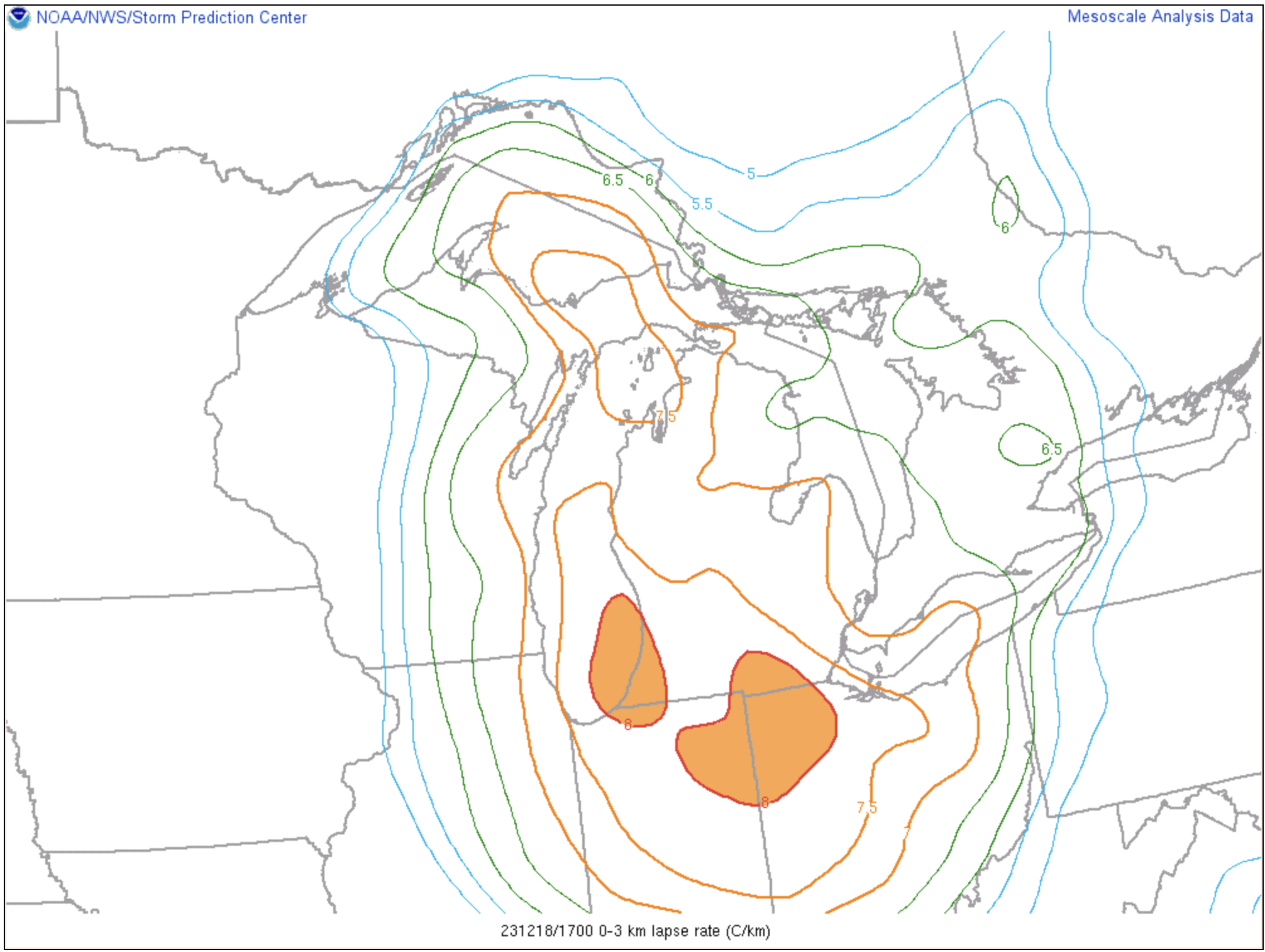
The RAP KBNA 23UTC analysis sounding showed that lapse rates were not particularly steep, and MLCAPE values were generally on the low side (near 500 J/kg). However, wind profiles became increasingly favorable for longer tornado pathlengths going into the mid to late afternoon hours across WRN/Middle TN and WRN/SCNTRL KY, though model guidance may have been several hours late in the generation of those wind profiles. Nevertheless, using the 23UTC KBNA RAP analysis sounding, the algorithm I'm testing yielded a predicted tornado pathlength of 54.6 km (or 34 miles), which was around 14 km less than the observed pathlength. It should be noted that this pathlength forecast was valid for Nashville, which was several tens of miles south-southeast of where the long-track event occurred, thus the pathlength prediction might be different if a closer analysis sounding was available. 

A few factors that favored longer-track tornadoes this day included the shape of the hodograph, which featured a classically strong veering wind shear profile from the surface through 10 km AGL. That profile likely aided in strong storm-scale lifting via cold-pool shear interactions as well as updraft-shear interactions. In addition, storms moved fairly quickly downstream, which increased storm-relative inflow as well as downstream translation. Furthermore, the thermodynamic profile, though not particularly unstable, was sufficiently unstable to maintain renewed storm-scale updraft development, and the thermodynamic profile was cool and humid, which likely precluded excessively dense/stable surface cold pool development and perhaps excessive updraft dilution via mixing with the environment. Finally, a quasi-discrete mode of convection was observed. Factors that inhibited longer pathlengths included only moderate 0-1 km AGL mean streamwise vorticity (around 0.0155 s-1 from the 23UTC KBNA RAP sounding).

One final note, I am testing a new method for predicting supercell motion, and this new method solidly outperformed the ID Method. The velocity error for the u-component of motion was -0.5 m/s for the new technique versus 2.9 m/s for the ID Method. And the error for the v-component of motion was 1.6 m/s for the new technique versus 9.7 m/s for the ID Method. A robust test dataset will be presented in a future paper.


250 mb valid 00 UTC 12/10/2023.

500 mb valid 00 UTC 12/10/2023.

700 mb valid 00 UTC 12/10/2023.

850 mb valid 00 UTC 12/10/2023.

925 mb valid 00 UTC 12/10/2023.

Surface observations valid 22-23 UTC 12/9/2023.

KBNA RAP analysis sounding valid 23 UTC 12/9/2023.

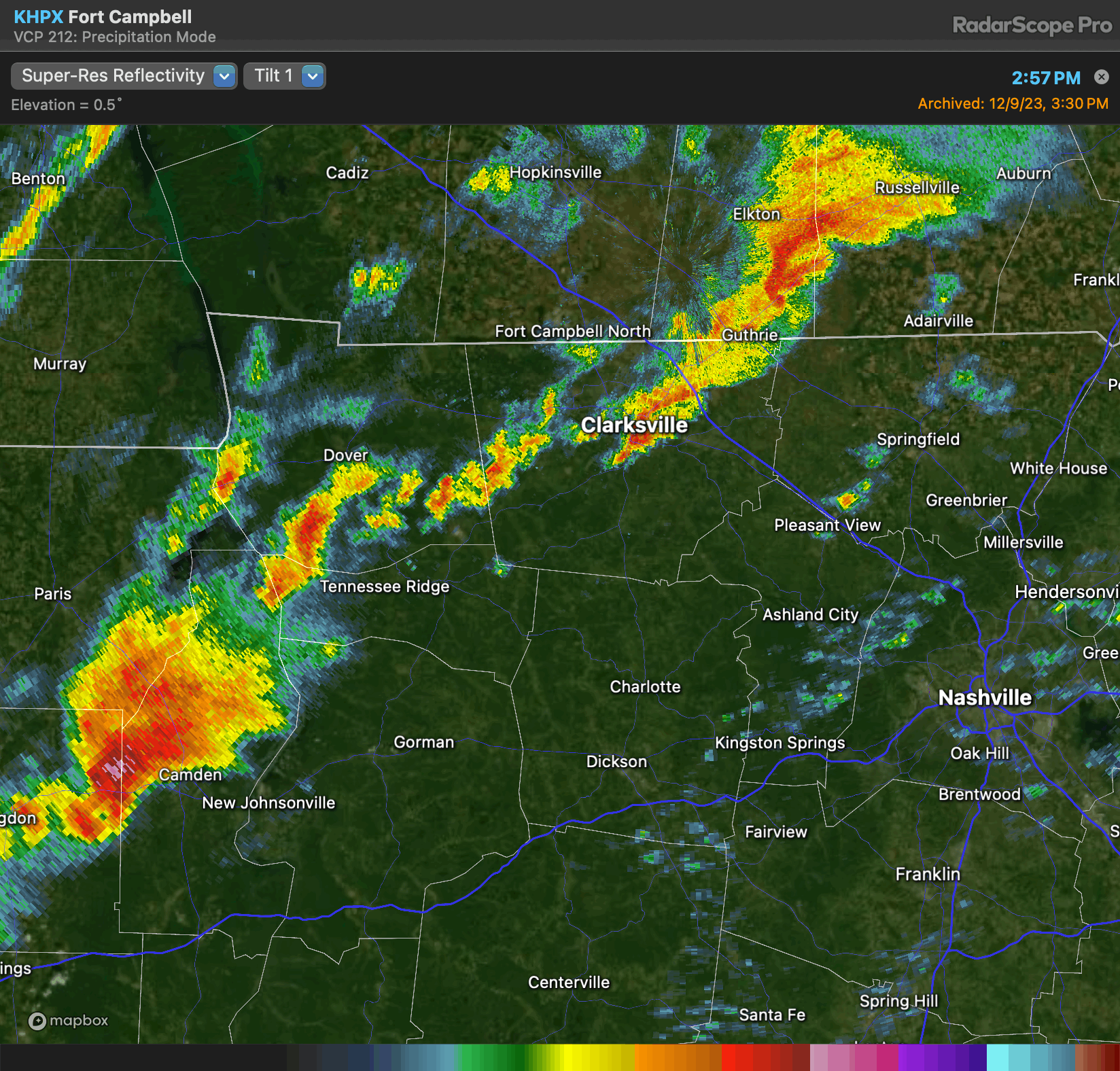
KHPX base reflectivity valid during the time of tornado occurrence.

KHPX base velocity valid during the time of tornado occurrence.

Storm Chase // 16 April 2024 // Southeast Iowa Tornadic Supercell

 I chased southern Iowa on April 16th and was rewarded with an intense EF2 producing tornadic supercell west of Burlington, IA. I departed F...