I did a day hike with my mom in Palo Duro Canyon State Park south of Amarillo, TX on Saturday 4/21. As crazy as it sounds, she actually climbed above 13,000 feet on Pikes Peak the day before, but had to turn back due to deep snow.
We decided to do the Lighthouse Trail, which is an easy 3 mile stroll that leads to the most popular canyon formation in the park (called the "Lighthouse"). Unfortunately, we made an erroneous left turn during the early stages of our hike, which added an additional four miles to our trip. This trail eventually led to a dead end, which is when we realized we made an error, so we turned around, and eventually regained the correct trail. Luckily, the high temperature was only around 80F, so our mistake wasn't too physically draining. As we approached the Lighthouse, a steep 100-200 foot cliff must be gained. The combination of loose dirt on a 50-degree slope almost made me wish I had crampons. After this crux section is finished, you are able to scramble up on top of a flat table like area of mudstone, and then scramble another 50 feet to the top of a buttress, which is adjacent to the Lighthouse.
On the way home, I decided to find out how many times I could listen to Frank Black's album Teenager of the Year between Amarillo and Oklahoma City. Averaging 70-75 mph, the answer is 3 times.
I finally saw my first Oklahoma tornadoes on Friday, April 13 2012. This was the "day before the day," characterized by an upper trough located well west of the region, with moisture returning northward into the Great Plains aiding in a tornado threat that increased near sunset as the low-level jet stream intensified. A co-worker at the SPC, lead forecaster Corey Mead, published an excellent paper on this particular type of environment, which can be found here: http://www.ejssm.org/ojs/index.php/ejssm/article/view/84/66
Of course, the nocturnal sig-tor threat didn't materialize. But, tornadoes occurred nonetheless, including a tornado that moved through Norman, OK just after I departed for southwestern Oklahoma.
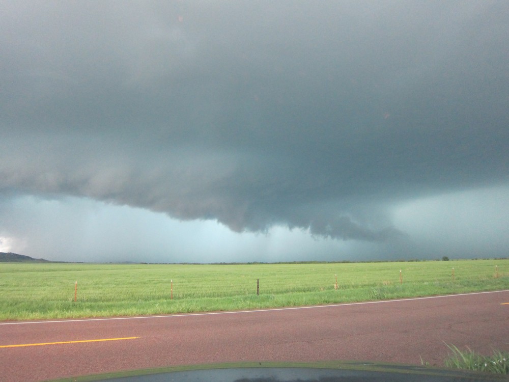
I had to work a fire weather shift on this day, but was able to leave work early. I traveled west on I-40 initially, just in case convection surged north with any intensification in the LLJS. As it turned out, a supercell in southwestern OK made very little east-northeastward progress during my drive. As I drove south on highway 54, this storm came into view, and it was quite apparent that it was an HP.
I sat along the side of 54 for quite a while, unsure if the storm would move due east along highway 62, or move northeast toward my position near Cooperton, OK. I watched the storm go through a rain-wrapped mesocyclone occlusion, after which it then then moved northeast. After the initial meso occlusion, it developed a new wall cloud beneath a milky updraft (it had problems removing precipitation away from the updraft, thus its HP character). Then, a new low-level mesocyclone developed north of the established wall cloud. I drove north to a position about 1 mile southeast of this new meso, and waited patiently to see what it would do. Low-level rotation was obviously strengthening...then a rain curtain wrapped around the meso, and my view of the base was cut off. I decided to slowly move north into the edge of the hook echo. The time was now around 7:30pm. All of a sudden, I saw what appeared to be the entire updraft base at the ground, a giant cylinder emerging out of the rain. I looked northwest, and the edge of a large tornado was directly in front of me, about a quarter mile away. There was no time to take pictures. I quickly put my truck in drive and sped off to the south for about a mile. The rain curtains were rapidly swirling cyclonically around me...I felt relieved when I finally exited the hook echo. Several good YouTube videos of this tornado have been posted...here is a sample:
This tornado dissipated fairly quickly. I then followed the storm northeast. The sun set, and the LLJS was definitely cranking up. I eventually navigated through the RFD and repositioned myself along the edge of the updraft. Initially, the occluded portion of the updraft to my northwest looked favorable for another tornado. But that area got a cold look, and a new meso formed to my north-northeast. A v-shaped lowering developed, back-lit by lightning, and a brief 20-second tornado occurred. I don't have the exact time of this event, but apparently it touched down close to the town of Carnegie, OK. In addition to this tornado, it was eerily cool listening to the inflow scream through the powerlines positioned along the side of the road.
I then decided one nocturnal tornado was enough for me and ended the chase. However, the battle back home through pouring rain was hell, but I eventually made it back to Norman shortly after 11pm, and celebrated a successful chase by having a couple of beers with a few friends.
Cindy McCloskey and myself tackled Elk Mountain via the Charon's (pronounced Karen's) Garden Wilderness Trail. After taking a short side-trip up a rock buttress, we returned to the main trail, and then began ascending a gully filled with medium sized boulders located on the northwest flank of Elk Mountain. After gaining several hundred feet, we then veered south up a second gully, which gave access to an expansive slab of exposed granite that was sloped at a 30-40 degree angle. We smeared up the granite slab, and before we knew it, we reached the large flat summit. We then made a southeastward traverse across the top of Elk Mountain, and regained the class 1 trail that leads north toward the Sunset Lake picnic area and parking lot. We made a detour along a trail segment that followed a stream, reached the picnic area, turned west, and regained the Charon's Garden Trail. Halfway through the trail, we encountered the expansive boulder field that resides at the base of Elk Mountains western slope...the boulder hopping was great. Next, we skirted past a seasonal waterfall, regained the rocky trail, and reached the end of our adventure soon after. The traverse/loop was around 6 miles roundtrip, took 3 hours to complete, and the climbing didn't exceed class 3.