Thursday, February 29, 2024

Late February Tornadoes Across the Midwest

 I ventured out to the Illinois/Northwest Indiana border during the late afternoon of February 27th, 2024 to see if thunderstorm initiation could take place near the warm sector of a deepening surface cyclone. Shear profiles would be more than favorable for tornadoes if storms did form near my location, but no storms formed, likely due to neutral to slightly anticyclonically curved mid/upper level flow spreading across Indiana which prevented the cap from fully eroding. Meanwhile, strong low-level convergence developed in the vicinity of a surface low pressure center over northern Illinois, which aided in surface based thunderstorm development. I had considered chasing that area, but model forecast soundings showed a consistent near-surface stable layer that prevented me from committing to that target. Plus, storms would drift east into the Chicago metro area with time, which I found to be a horrible chase scenario. 

Otherwise, a supercell formed during late afternoon very close to the previously mentioned surface low near the Iowa/Illinois border and produced a 4.5 km pathlength tornado with a duration of 8 minutes. With input from a RAP analysis sounding, the algorithms I'm testing yielded a predicted tornado pathlength for that area of 10 km with a 9.9 minute duration. Additional tornadic storms formed downstream from the surface low, just west of Chicago, with the maximum observed pathlength being 13 km and a duration of 10 minutes. The max predicted pathlength via RAP analysis soundings was 25 km with a duration of 25 minutes...a slight over-prediction compared to observations. Much later in the night, a QLCS advanced into western Ohio and produced a tornado with a pathlength of 22 km and duration of 14 minutes. My algorithms predicted 29.7 km and a duration of 23.6 minutes. Additional data and analysis is provided below.

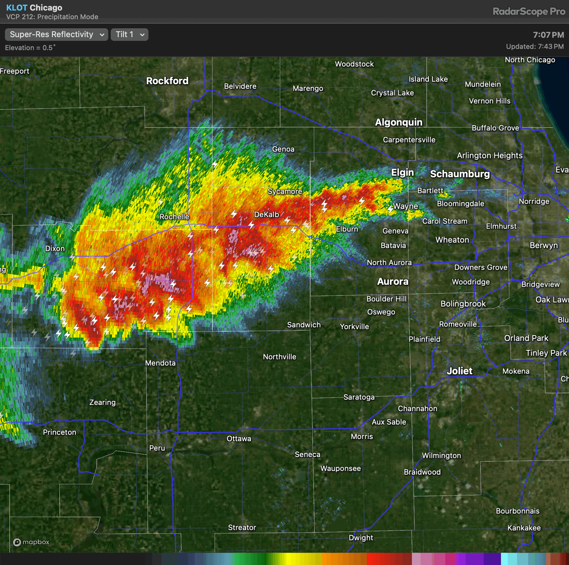
KLOT base reflectivity during the time of max tornado development. Storms would quickly congeal into a bow echo after this time.

KLOT base velocity during the time of max tornado development.

250 mb analysis valid at 00 UTC 28 February 2024. Streamlines were neutral to slightly anticyclonically curved across much of the Midwest, which likely aided in suppressing storm development across much of the warm sector.

A crude subjective surface analysis with frontal boundaries, isotherms, and surface streamlines analyzed. Late afternoon/early evening severe storm development occurred very close to the region of strongest low-level convergence which aided in offsetting initially marginal large-scale ascent.

RAP analysis sounding valid near the time of the first tornado near the Iowa/Illinois border.

RAP analysis sounding valid near the time of tornado activity occurring in the vicinity of the Chicago suburbs.

RAP analysis sounding valid near the time of QLCS tornadoes in western Ohio.

Tornado pathlength and longevity guidance at the time of tornado activity near the Iowa/Illinois border. For reference, observed tornado pathlength and duration was 4.5 km and 8 minutes.

Tornado pathlength and longevity guidance at the time of tornado activity near the Chicago suburbs. For reference, max observed pathlength and duration was 13 km and 10 minutes.

Tornado pathlength and longevity guidance at the time of QLCS tornado activity in western Ohio. For reference, max observed pathlength and duration was 22 km and 14 minutes.


Monday, February 19, 2024

Sedona Hikes and Scrambles YouTube Video

 I added an iphone generated movie of my recent hiking experiences in Sedona, Arizona to my YouTube channel. Check it out here [https://www.youtube.com/watch?v=-AqjX1x5rxE].

Saturday, February 17, 2024

Sedona Red Rock Caves

I had the chance to explore a series of caves etched into the red rock buttes surrounding Sedona, AZ during January 2024. In terms of cave epicness, the Subway Cave was at the top of my list. The cave requires a couple of miles of easy hiking starting from the Boynton Canyon Trailhead. Upon arrival, you have the option to scramble up a slick slab of rock that takes you into the heart of the cave, or you can bypass the scramble and walk along the side of a cliff that also gives access to the interior portion of the cave. I did the slick rock scramble up, which was easy, and then did the downclimb, which was not so easy. Nevertheless, I had the full Subway Cave experience, which included adjacent ancient cliff dwellings etched into the side of steep canyon walls. View the map location for the Subway Cave here.

Second on my list was Soldiers Pass Cave, which involved an easier hike and scramble. The cave itself consisted of a long chamber that was slit down the middle by a giant vertical crack. It was neat, and I appreciated the small natural window that gave a view of the outside surrounding terrain. The last cave I visited was the Birthing Cave. Not much to say about this one. Pretty unremarkable, but still a nice hike and good view of the surrounding desert.


Thursday, February 15, 2024

Sedona Sunrise Followed by a Scramble up Bell Rock

 I was treated to a glorious color-filled sunrise in Sedona, AZ during early 2024. Views to the south at the Sedona Airport vista were filled with reds and orange, while the buttes to the east and north glowed in warming pre-day light. I captured a couple of landscape images during the sunrise experience, and then headed over to Bell Rock with Amy Schreiber. We hiked to the base of the Bell, and then began a fun red-rock scramble up short platforms of rock, occasional cracks and slots, additional smooth rock, and then a short class 5 climb. The class 5 climb required a 15 foot ascent up a crack, then a stretch across a void in order to acquire easy rock that then led to the top of the Bell Rock hike. We soaked in views, Amy obtained another 20 feet up a pillar of exposed rocks, and then we headed down. The down climb on the short class 5 section was briefly sketchy, but the sketch was short and sweet and we were cruising back to our car in no time. Bell Rock is definitely a Sedona classic that should not be missed...map can be viewed here.


Wednesday, February 14, 2024

Sedona: Cathedral Rock Hike/Scramble

 Amy Schrieber and myself hiked up Cathedral Rock near Sedona during early 2024. There were a few sections of easy scrambling on grippy mudstone. In addition, we took a side trail down the back side of Cathedral during the return to the Shuttle Bus parking lot. Essentially, once we reached the vista point at Cathedral, we took a left, scrambled up to a narrow gap, then down along a maze of trails that bypassed some cliffy sections. We then curved left around the back side of Cathedral and hooked up with the main trail that leads back to the parking lot. It was a pretty fun one hour excursion with great views of the surrounding desert/Sedona area. Map of Cathedral Rock can be found here.


Tuesday, February 13, 2024

Another Grand Canyon Day Hike

Amy Schreiber and myself hiked the South Kaibab trail down to the Colorado River and then back up during late January 2024. The weather was exceptionally awesome during this hike...we definitely got lucky as heavy snow blasted the region only a week or two later. Otherwise, due to numerous breaks we utilized to photograph the sunrise across the canyon during our early morning descent, it took us 5 hours to go down and surprisingly 4 hours to go back up. The ascent wasn't too bad in my opinion. I felt stronger compared to my experience a year ago hiking up the Bright Angel Trail. A google map of our trail location can be found here.


Saturday, February 10, 2024

Early Season Significant Tornado: Southern Wisconsin/Northern Illinois

 A frontal wave that was handled well by model guidance several days in advance progressed east across the Midwest/Great Lakes Region on 8 February 2024. Dewpoints in the 40s to low 50s spread north in advance of a surface cold front, and MLCAPE values up to 500 J/kg developed during peak heating. Strong boundary layer destabilization also occurred along and in the wake of the cold front, and high based convection developed across the frontal zone as large-scale ascent increased across the region, with activity then deepening and becoming surface based as it encountered greater moisture east of the front. Wind profiles were very favorable for supercells across the warm sector. A couple of those rotating storms produced tornadoes, including a 39 km pathlength tornado with a duration of 36 minutes that produced high-end EF2 damage in the vicinity of Evansville, Wisconsin. The tornado pathlength/duration algorithm that I have been testing yielded a predicted 25 km pathlength with a 31 minute duration using input from NAMNEST forecast soundings across southern Wisconsin. Algorithm output can be found below within the hodograph inset.

Possible key features impacting this event: 1) Based on the WPC surface analysis, the tornadic storm in southern Wisconsin occurred near the intersection between a warm front and cold front. 2) The shear profiles were exceptionally favorable for rotating storms. 3) Steep lapse rates and a fully destabilized boundary layer airmass compensated for the seemingly marginal low dewpoint surface airmass. 4) Storm mergers in southern Wisconsin may have assisted in storm augmentation and subsequent tornado activity.


Reflectivity imagery during the time of the southern Wisconsin significant tornado.

Long-lived tornadic rotational velocity couplet moving northeast across the Evansville, Wisconsin region.

SPC storm reports.

Detailed summary of the tornado damage survey for the EF2 Evansville, WI tornado.

Favorably difluent left exit region of a 250 mb jet spreading east across WI/IL/Great Lakes region during the late afternoon of 8 February 2024.

925 mb thermal wave moving east toward WI/IL during the time of significant tornado activity.

Steep 0-3 km lapse rates spreading east in tandem with the progressive surface cold front.

SBCAPE values generally not exceeding 500 J/kg across the warm sector.

WPC surface analysis during the time of tornadic activity. Note the warm front/cold front intersection near the WI/IL border.

SPC objective surface analysis of temperature, dewpoint, and MSLP. Surface dewpoints were very low (40s to perhaps low 50s) across southern WI and northern IL.

NAMNEST proximity sounding taken from the time and place of significant tornado activity in southern WI.

Tornado pathlength and longevity guidance shown within the hodograph plot inset using input from NAMNEST proximity soundings in southern WI. These predicted values compare favorably with the damage survey conducted for the Evansville, WI EF2 tornado.


Storm Chase // 16 April 2024 // Southeast Iowa Tornadic Supercell

 I chased southern Iowa on April 16th and was rewarded with an intense EF2 producing tornadic supercell west of Burlington, IA. I departed F...