Monday, June 26, 2017

Landscape Photography

I'm still sifting through my photography portfolio (located here), and here are a few more shots that missed the final cut:

Aurora above Auke Bay - Juneau, Ak.
Alaska Range; Denali is on the right.
Great Sand Dunes National Park, Colorado.
Starry skies above radio towers - Kneeland, CA.
Kneeland, California.
Kneeland, CA radio towers.
Starry skies, radio towers, and a toyota truck - Kneeland, CA.

Tuesday, June 20, 2017

Sleeklens - Through the Woods Workflow

I was given the opportunity to review landscape photography post-processing presets and brush tools offered by Sleeklens. The "Through the Woods Workflow" package, which is compatible with current versions of Adobe Lightroom, features 42 landscape brushes, 80 landscape presets, and 4 video tutorials that provide simple easy to follow instructions on how to set up and use the workflow in Lightroom. Admittedly I am a novice when it comes to the intricacies of Photoshop and Lightroom. Therefore, I particularly appreciated the video tutorials, which had me ready to start processing images in a matter of minutes.

I recently visited the Great Plains of eastern Wyoming, and decided to test out the Sleeklens workflow using two pictures that I took during that trip. Both images were made using the RAW setting in my Canon 5d mark iii with a 25mm Zeiss lens. The first picture features an extreme dynamic range pointing into a setting sun.  I started processing this image by going through the suggested workflow presets, always being mindful that my post-processing style is best characterized as subtle.  I don't like highly saturated contrasty HDR-esque images. Thus, I chose presets that yielded rich colors that gradually transitioned from one hue to another...at least that was my goal.

Here is the original RAW file (click to enlarge):


The image is obviously struggling due to the dark foreground and the very bright background. Fortunately, I made an exposure that wasn't completely blown out at the bright or dark ends of my histogram. I used the Sleeklens workflow to first darken the highlights. I then deepened the blues in the sky, followed by a color enhancement, and then sharpening. I then manually decreased the color vibrance and clarity slightly in order to render a more believable sunset. After this step, I used the Sleeklens brushes to add a golden hue to the foreground, followed by darkening shadows near the clouds and sun rays, and I brightened the highlights throughout the picture.  The final image looks like this (click to enlarge):


The next image I processed featured a dynamic range that was less extreme when compared to the first example.  Here is what the RAW image looked like (click to enlarge):


This JPEG doesn't look too bad coming straight out of the camera, but clearly it could use a little bit of color enhancement to make it pop.  Once again I utilized the Sleeklens workflow by first employing their cinematic setting, followed by a darkening of shadows, deepening the blue in the sky, cooling down the white balance, and applying a global sharpening to the image.  I then manually adjusted the color curve slightly to enhance the yellows and oranges, and then readjusted the white balance toward a slightly warmer value.  After that, I used the Sleeklens brushes by further darkening the shadows in the grass and around the fence posts, and then brightened the highlights across the prairie, the fence posts, and the small cumulus cloud hovering above the scene.  The final image looks like this (click to enlarge):


To summarize, I started off with two RAW files that lacked color vibrancy, and one in particular suffered greatly due to a very dark foreground and very bright background. I followed the Sleeklens workflow, and was able to bring out the colors in both images, and also control the shadows and highlights using an array of presets and brushes.  On occasion, the presets produced an image that I considered a bit overdone, especially in terms of color saturation. However, I was able to easily fix that by applying manual adjustments to the sliders on the right side of the Lightroom interface.  Naturally, the final look and feel of an image comes down to the tastes and preferences of the artist, and no amount of presets will yield a perfect final image...fine tuning will always be required.  The Sleeklens presets and brushes pushed my two example images in the right direction; the final touches were up to me.

I want to thank Sleeklens for sharing their workflow, and giving me the opportunity to review it.  You can follow Sleeklens online via Pinterest.  Here is another link to the Workflow.  Sleeklens also offers professional photo editing services, and additional Lightroom presets.

Thursday, June 15, 2017

June 12th, 2017 - Southeast Wyoming Storm Chase

I caught a morning flight from San Francisco to Denver on my birthday in order to chase a seemingly perfect High Plains supercell tornado environment.  After securing a rental car at DIA, I drove north on I-25 toward Cheyenne.  During the drive, I debated on whether to chase far northeastern Colorado, or continue north and chase southeast Wyoming.  Short-term model guidance seemed to indicate the best environment would develop in Wyoming by late afternoon, with moist upslope easterlies in northeast Colorado eventually being overtaken by dry hot downslope southwesterlies.  So I continued to Cheyenne, refueled, and then blasted north toward a strengthening supercell.  I reached this storm as it was crossing I-25 in Platte County.  The storm displayed classic supercell characteristics on radar, including strong rotation, and was promptly given a tornado warning by NWS Cheyenne.

I then moved east and north with the storm, accompanied by a caravan of other chases, through rural Wyoming.  The storm developed a large wall cloud after going through an initial mesocyclone occlusion.  It was at this stage that I thought a tornado would be imminent.  However, the storm occluded a second time, and then a third without producing a tornado.  During the third occlusion, large plumes of dust were kicked up by an intense RFD.  In addition, the third occlusion was accompanied by intense upward vertical motion, yet still failed to produce a tornado.  I then got cut off from the storm by a mud road...which admittedly, I could have attempted to drive on, but would have taken the risk of getting stuck, and I would have driven through the rear flank precip/hail core, which is a part of the storm I desperately wanted to avoid.  In addition, my rental car indicated my right-rear tire was loosing air.  Fate and luck were against me, so reluctantly I turned the car around and searched for classic High Plains scenery, that I could use to salvage my trip with a beautiful landscape photograph.  I was in luck; I found a gorgeous scene that you can view here.

Strong mesocyclone occlusion with classic clear slot.
Plumes of dust being kicked up by a strong RFD.
Third mesocyclone occlusion that observed.  The storm tried very hard to produce a tornado at this stage.
Another view of the third occlusion.  A small quasi-horizontal funnel is tucked up under the occluded base.
Mud run...game over.
250 mb - Valid 00Z 13 June 2017.
500 mb - Valid 00Z 13 June 2017.
850 mb - Valid 00Z 13 June 2017.
Surface observations valid 22Z 12 June 2017.

Visible Satellite Image - Valid 2045Z 12 June 2017.

SBCAPE valid 21Z 12 June 2017.
0-8 km Bulk Shear valid 00Z 13 June 2017.
0-1 km SRH valid 00Z 13 June 2017.
Fixed Layer STP valid 00Z 13 June 2017.

Wednesday, June 14, 2017

Landscape Images

In a continued effort to refine my photography portfolio (click here), I've added the following pictures, found below,  that don't quite make the cut, to my blog...

Spruce Tree House - Mesa Verde Colorado
Hoover Dam - Nevada/Arizona Border
Coyote - Death Valley California
Death Valley California
Humboldt County, CA Redwood Trees

Saturday, June 03, 2017

Great Plains and Colorado Plateau Roadtrip


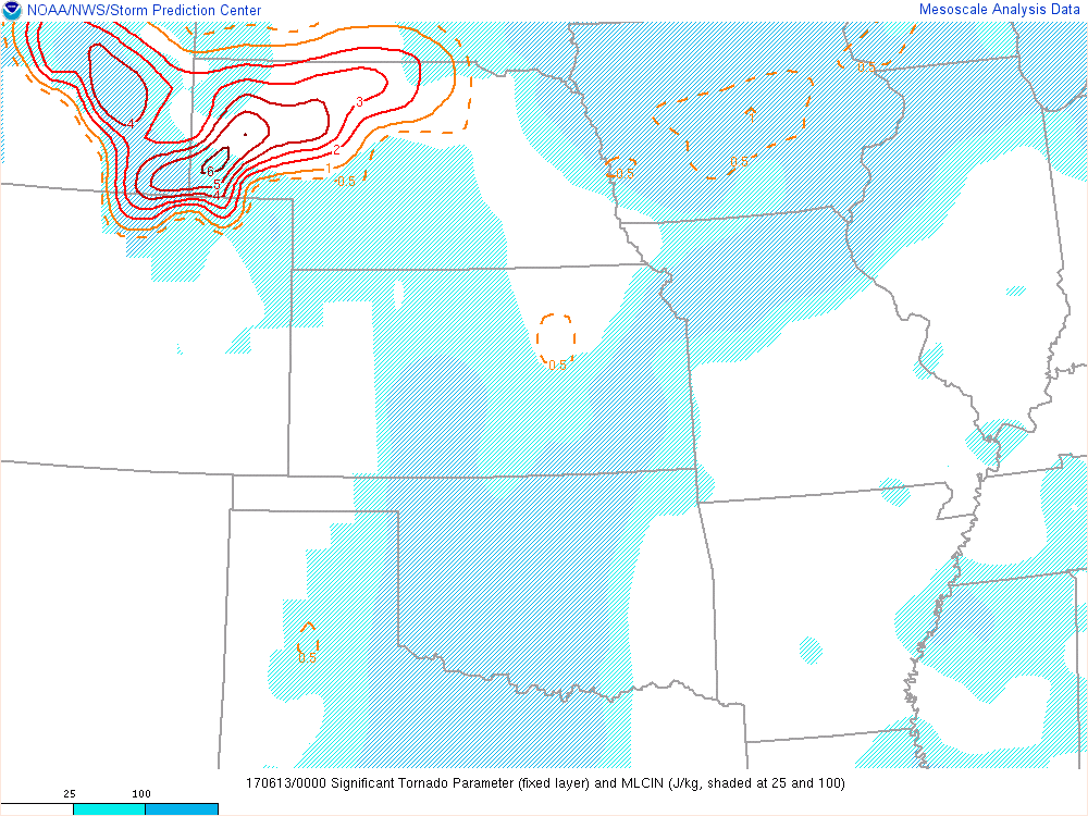
I hit the road, and the skies, during late May, originally planning on ~2 weeks of storm chasing in the Great Plains.  However, Mother Nature had different plans as an upper ridge developed over the western U.S. and troughing occurred over the east.  This eliminated tornadic supercell potential for the most part over the middle of the country.  So, I made the best of the situation and headed west from Oklahoma City toward the Colorado Plateau.  First, however, I made an intermittent stop at Great Sand Dunes National Park, which is located in the San Luis Valley in southern Colorado.  Photography paid off big time at this location...I captured some fairly impressive scenes as the sun rose over the Southern Rocky Mountains and slowly bathed the dunes in warm light.  I also discovered a cheap bare bones restaurant in Alamosa called the Lamplighter Restaurant.  The bacon and French Toast were perfect after slogging across massive sand dunes during the morning.

I left Alamosa after my breakfast at the Lamplighter, and headed west on highway 160 toward Durango.  There is a magical valley I encountered along the way, roughly between Pagosa Springs and South Fork.  Forested volcanic cliffs rise above a grass valley, waterfalls cascade down the cliffs, and the entire scene is framed by rugged mountains.  I think this area has high photographic potential during the fall.  Anyways, after gassing up in Durango, I headed south into New Mexico and toward Ship Rock.  I was going to spend the night in the area and photograph Ship Rock in morning...but after reading about how limited the access to the rock formation was, due to various concerns by the Navajo nation, I decided to skip north into southeast Utah.  I spent the night in Blanding, UT, which doesn't have a whole lot going for it, but at least the lodging was cheaper than what I would encounter in Moab the next night.

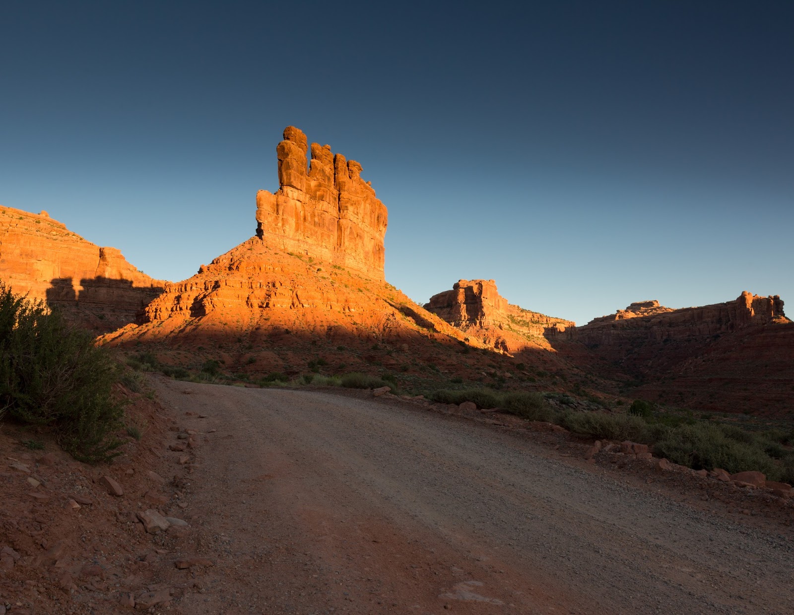
Early in the morning, I drove south of Blanding and into the Valley of the Gods.  This area is very similar to Monument Valley (which is only a short distance farther south), with large eroded mesas dotting the landscape in every direction.  The morning sun turns these structures blazing red and orange...a landscape photographers dream.  After photographing Valley of the Gods, I drove up a road called Trail of the Ancients, which ascended 3000 feet up to the rim of a plateau, twisting and turning next to thrilling drop offs into the valley below.  I tried to take a photograph that depicted just how amazing this road is, but all attempts failed to convey the sense of exhilaration.  Trail of the Ancients leads to Cedar Mesa, which is where Fallen Roof Ruin is located.  After paying a small BLM fee, I parked, hiked down into a canyon, and after a mile or so, came upon an ancient ruin embedded within the side of the cliff...the so called Fallen Roof Ruin, which is named due to slabs of rock falling from the cliff surrounding the ruin.  I spent hours here watching the reddish glowing light change around the structure, and also pondered what kind of life the ancients must have lived in the adjacent canyon eons ago.

Unfortunately, my next stop was Moab, which is a busy touristy town that is full of high priced lodging that I grudgingly paid for out of desperation and exhaustion.  Luckily, the sleep was good, and after eating breakfast at Pancake Haus, I drove an hour south to the Needles section of Canyonlands and hiked the Chesler Park Loop trail.  This trail was a great way to experience a less-visited portion of the park.  The scenery included up close views of needle like spires, long expansive vistas atop rock outcroppings, and a slot canyon that surprisingly did not form due to the erosional forces of water.  I highly recommend this hike...though I can't imagine doing it during the hottest times in summer.  

After my hike, and after finding another over priced room in Moab, I headed to Dead Horse Point.  While every other photographer safely congregated at a state sanctioned overlook of the canyons below, I walked to the edge of a 3000 foot drop and obtained some spectacular pictures of the setting sun illuminating the adjacent canyon walls. I recommend people continue photographing this location at least 20 minutes after sunset, as the sandstone rocks take on an red/orange glow beneath the cooler blue colors of the sky.

My time in Moab came to an end quickly, and I departed east bound on I-70...past the Colorado Monument in Grand Junction, up the Colorado River through Glenwood Springs, across the crest of the Rockies, through Denver at rush hour, eventually taking I-76 to I-80 in Nebraska, then east along the Platte River to Omaha. I spent the next several days photographing downtown Omaha during the evening, and obtaining few good results in my attempts.  I also had a good time reconnecting with family and old friends.  After 5 days in Omaha, I headed back to Oklahoma City, completing a gigantic loop.  My road trip was complete.  On a side note, I had a layover in Los Angeles, and I am 99.999% certain that rock climber Kevin Jorgeson, famous for climbing the Dawn Wall in Yosemite with Tommy Caldwell, was sitting across from me at an airport bar.

Great Sand Dunes National Park - Colorado.
Valley of the Gods - Utah.
Fallen Roof Ruin - Utah.
Dead Horse Point - Utah.
Chesler Park Loop - Canyonlands, Utah.
Dead Horse Point - Utah.
Omaha, Nebraska.
Omaha, Nebraska.
Platte River State Park - Nebraska.

Storm Chase // 16 April 2024 // Southeast Iowa Tornadic Supercell

 I chased southern Iowa on April 16th and was rewarded with an intense EF2 producing tornadic supercell west of Burlington, IA. I departed F...