Overnight convection left a pronounced outflow boundary draped across West Texas and Eastern New Mexico by mid to late morning of June 5th. I recognized that possible scenario the day before, and thus drove all night from Omaha to the Texas Panhandle, slept a few hours along an I-40 rest stop, and then made my way to a spot southwest of Lubbock by midday. Rich moisture with boundary layer mixing ratios exceeding 15 g/kg were present across West Texas and eastern portions of New Mexico, pooling along the outflow boundary that was reinforced by differential heating via stratus to the north and sunshine to the south. The exceptional moisture and steep midlevel lapse rates yielded large MLCAPE values, while low-level southeasterlies beneath 50+ kt upper-level west-southwesterlies made supercells all but guaranteed. That mode of convection combined with enhanced near-surface horizontal vorticity along the outflow boundary favored an elevated risk of tornadoes.
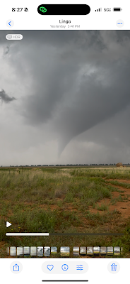
I noticed a deepening zone of cumulus in visible satellite imagery west of the TX/NM border, which was also in a spot favored for convective initiation in the HRRR. I thus began driving northwest, and as I approached Lingo, New Mexico, an incipient supercell began to emerge with an incredible anvil forming above a vertically towering column of buoyant white updraft. The base soon came into view and a broad bowl shaped wall cloud was present. Tornadogenesis seemed imminent, and sure enough, an occlusion took place and a brief tornado developed. I then followed the storm east-southeast and watched it occlude several more times. Landspouts, gustnadoes, and possibly an additional weak mesocyclonic tornado were observed. Then, as the storm and a massive caravan of chasers approached Morton, Texas, several zones of low-level updraft rotation began to consolidate immediately north of HWY 114. A classic low-level mesocyclone and wall cloud formed, which I viewed from the south, and beneath the wall cloud, a cloud of thick dust was rotating violently, and quickly contracted into a large tornado. The low-level structure was fantastic, and the lighting was excellent, which made for great photography.
After the large tornado, the supercell turned into a giant vacuum cleaner, sucking in huge quantities of Texas dust. Viewing a tornado under those conditions was impossible, so I settled for some structure photography from time to time. I then entered the west side of Lubbock, which was unnerving, as a potentially tornadic supercell boxed me in to the west, and a dense urban environment was present to the east. I thus decided to race east across Lubbock ahead of the approaching storm. I found an elevated position overlooking downtown to my west. This is when additional tornadoes formed along the western periphery of Lubbock, which I could not view due to darkness setting in under the storm. Nevertheless, the updraft structure did not disappoint, which I observed for 30-60 minutes before exiting to the north just ahead of a core of large hail.


