Friday, June 06, 2014

Buckskin Gulch - Utah

I hiked Buckskin Gulch, located in southern Utah, during late May.  After walking a mile along a dry creek via Wire Pass, I entered narrow sections of slot canyons, with the rim of these canyons becoming progressively taller.  After another mile or so, Wire Pass connected with the main canyon, in what can be described as a large amphitheater like area surrounded by steep sandstone cliffs.  Petroglyphs are located at this junction, most of which depict animals such as deer.  I continued on from this point into a deeper and more narrow section of the canyon, with walls glowing purple and orange from the ambient sunlight striking the rim of the canyon above.  A decision was made to turn around a mile later due to dwindling daylight.  However, I plan to come back and explore the remainder of this long slot canyon that eventually connects up with the Paria River 15 miles from the entrance.

Petroglyphs located at the junction of Wire Pass and Buckskin Gulch.
Wire Pass creek bed.

Wednesday, June 04, 2014

Monument Valley Navajo Tribal Park

Visited the Monument Valley Navajo Tribal Park, which sits on the Arizona/Utah border (park website can be found here).  Instead of taking the circuitous auto tour, I hiked a loop around West Mitten Butte via the Wildcat Trail.  Overcast skies broke during the hike, with vivid blue skies standing out against white cumulus clouds and the orange desert sand and mudstone.  This resulted in excellent light for photography, with most of my pictures displaying a variety of rich colors.

Tuesday, June 03, 2014

Mesa Verde

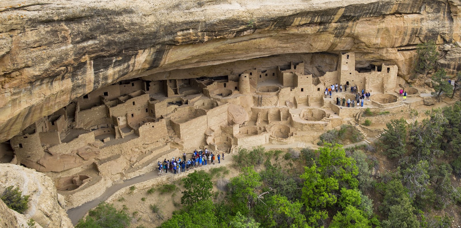
Made a visit to to the canyon dwellings of Mesa Verde, which were built by the ancient Pueblo people who occupied what is now called southwest Colorado.  The most popular ruins, such as Cliff Palace, are accessed only through park guided tours, so make sure to buy your tickets upon entrance to the park if you want to join one of the hourly caravans.  Otherwise, the less popular structures can be viewed up close by engaging in short self guided hikes.

Cliff Palace with guided tours in progress.
A type of Kiva at Spruce Tree House.
Flowering cactus and humming bird.
Spruce Tree House.

Thursday, May 29, 2014

Fisher Towers - Utah

Fisher Towers is located northeast of Moab, UT via highway 128, which follows the scenic Colorado River past sheer red rock canyon walls.  After driving past the turn off for Castle Valley, a right turn onto Fisher Towers road brings the immensity of these geologic wonders into view.  These gigantic sandstone formations are famous in the rock climbing world, having made the list in Steve Roper's and Allen Steck's 50 classic climbs of North America.  For those who aren't so vertically inclined, there are plenty of butte's and canyons to explore, as well as a handful of trails to hike.  Fisher Towers is an excellent alternative for anyone wanting to get away from the crowds and traffic that plague nearby Canyonlands and Arches National Parks.

Sunday, May 25, 2014

Great Sand Dunes National Park and a Landspout - 22 May 2014

A lame chase pattern drove Crystal Kerber and myself west into Colorado.  We decided to check out the Great Sand Dunes National Park.  Incredibly, as we drove north across the San Luis Valley toward the park boundary, a weak thunderstorm produced a landspout tornado.  The landspout appeared to develop a few minutes after a sheet of rain emerged.  After watching the landspout (which displayed multiple vortices as it dissipated), we explored the sand dunes for a few hours, eventually being chased back to our car as a second thunderstorm moved northwest off of the Sangre de Cristo mountains.

Northeast Colorado Supercell - 21 May 2014

Crystal Kerber and myself chased an HP supercell from the eastern suburbs of Denver east to Last Chance, CO.  After waiting for initiation in Limon, we headed west on I-70 as a storm matured over Denver.  We reached the cell as it began producing large hail and a few weak tornadoes over the eastern metro area.  The storm quickly developed into an HP supercell, with its rear flank filled with heavy precipitation and cold outflow.  The storm went through several interesting low-level mesocyclone cycles during the next few hours, but none appeared to pose a significant threat for tornadogenesis.  We finally let the storm go as the cell approached Last Chance.

Wednesday, May 21, 2014

Northeast Colorado Supercell - 20 May 2014

I observed a beautiful supercell with Crystal Kerber during the evening of May 20th.  We were heading west toward Limon, CO in order to be in position for a storm chase the next day, and as luck would have it, a supercell was moving southeast along I-70 between Denver and Limon.  At 630pm MDT, we reached Seibert, CO as the supercell moved east of Limon...we then headed north a few miles on highway 59, set up the tripod along the side of the road, and were treated to a text book perfect high plains supercell.  The storm went through several updraft cycles, eventually developing a helical look to its structure as it approached our location.  We eventually moved south out of the path of a hail core, then went west a few miles to watch the last rays of daylight strike the backside of the storm.


Monday, May 05, 2014

Thunder Mountain Summit

Crystal Kerber and myself summited Thunder Mountain at sunset...found a short gully that by-passes steep snow to the right.  We were be-knighted after watching the sun drop below distant peaks to the north, but it was totally worth it.  Unfortunately, we didn't make it back home until midnight, and I had to work a shift in the morning...talk about tired!

Mount Juneau

Springtime in Juneau, AK is amazing...clear skies, warm temperatures (relatively speaking), and calm winds...perfect for mountain climbing.  And thus, I felt obliged to take advantage of a glorious Monday afternoon by climbing Mount Juneau.  The route is steep as it departs Perseverance Trail, then levels out about half way up the mountain.  Snow melt is in full force and there were numerous stream crossings.  One in particular was pretty sketchy...a large slab of snow covered a large/steep cascading stream, and it required a bit of faith that the slab wouldn't break loose while crossing it.  After the stream crossings, I then began picking my own route up steep snow slopes.  The snow was wet and isothermal, and avalanche risk appeared minimal.  The summit came into view about an hour later, and soon I was at the top.  The views were glorious, as usual.  The descent back down Juneau was quick...I think I took ~3 hours to get to the top, but only 1.5 hours to get back to my truck.

Wednesday, April 23, 2014

Thunder Mountain - Juneau, AK

I ascended Thunder Mountain minus the last couple hundred feet.  Starting from the Jennifer Drive trailhead, the route meanders through a marsh, followed by a convoluted trail that branches off into unconnected side-trails.  After searching for 30 minutes, I finally found the trail that leads upwards toward the ridge line of Thunder Mountain.  The trail is very muddy, quite steep, and actually involves some class 3 moves over a few vertical sections of tree roots.  After 2 hours, I reached snowpack, and an hour later, I was above treeline right below the summit ridge.  However, a large cornice covered the narrow ridge...being unropped, I decided to skip the summit.  There was also plenty of evidence of small avalanches below the summit ridge.  The view was spectacular despite coming up short of the summit...all of Mendenhall Valley lay below me, as well as the Juneau Airport, and the inner channels to the west.

Mendenhall Valley.
Inner Channels west of Juneau, AK.
Slope beneath the summit of Thunder Mountain.

Family Adventures in the Rockies // Grottos Ice Caves/Mount Sherman

 My mom and nephew made a trip to central Colorado during early summer and we all had a blast hiking a couple of unique geological features,...